Topola geodata
Topola (Central Serbia) is a seat of a third-order administrative division; located in Serbia in Europe/Belgrade (GMT+2) time zone. In our database, there are 365 cities with bigger population. Compared to other cities in Serbia, 76% of cities are located further ↑North; 66.2% of cities are located further ←West and 83.4% of cities have lower elevation than Topola. Note1


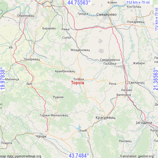
Topola GPS coordinates[2]
44° 15' 15.012" North, 20° 40' 57" East
| Map corner | latitude | longitude |
|---|---|---|
| Upper-left | 44.75563°, | 19.97938° |
| Center: | 44.25417°, | 20.6825° |
| Lower-right: | 43.7484°, | 21.38563° |
| Map W x H: | 112×112 km | = 69.6×69.6mi |
| max Lat: | 46.1° ⇑76% North |
| Topola: | 44.25417° |
| min Lat: | ⇓24% South 42.25846° |
| min Long | Topola | max Long |
| 18.9276° | 20.6825° | 22.77556° |
| W 66.2%⇐ | ⇒33.8% E |
Elevation
Elevation of Topola is 276 m = 906 ft, and this is 99.6 m = 327 ft above average elevation for this country.
| Max E: |
1421 m = 4662 ft | 16.6% |
| Topola | 276 m 906 ft | |
| Avg. | 176.4 m = 579 ft | |
Min E: |
49 m = 161 ft | 83.4% |
See also: Serbia elevation on elevation.city.
Geographical zone
Topola is located in North temperate zone (between Tropic of Cancer and the Arctic Circle). Distance of this Northern Tropic circle is 2314.7 km =1438.3 mi to South.| Distance of | km | miles | from Topola |
|---|---|---|---|
| North Pole | 5086.5 | 3160.6 | to North |
| Arctic Circle | 2480.6 | 1541.4 | to North |
| Tropic Cancer | 2314.7 | 1438.3 | to South |
| Equator | 4920.6 | 3057.5 | to South |


Nearby cities:
15 places around Topola: (largest is in red/bold)
• Aranđelovac
11.4 km =7.1 mi,  301°
301°
• Batočina
33.7 km =20.9 mi,  109°
109°
• Gornji Milanovac
30.9 km =19.2 mi,  214°
214°
• Knić
36.5 km =22.7 mi,  175°
175°
• Kragujevac
32.4 km =20.1 mi,  144°
144°
• Lapovo
34 km =21.1 mi,  103°
103°
• Lazarevac
37 km =23 mi,  293°
293°
• Ljig
35.5 km =22.1 mi,  265°
265°
• Mladenovac
20.6 km =12.8 mi,  3°
3°
• Prislonica
38.9 km =24.2 mi, 210°
• Rača
23.7 km =14.7 mi, 97°
• Smederevska Palanka
25.2 km =15.7 mi,  60°
60°
• Sopot
30.8 km =19.1 mi,  343°
343°
• Svilajnac
41 km =25.5 mi,  93°
93°
• Velika Plana
32.6 km =20.3 mi,  74°
74°
Sources, notices
• [Note1] Compared only with cities in Serbia existing in our database
• [Src1] Map data: © OpenStreetMap contributors (CC-BY-SA)
• [Src2] Other city data from geonames.org with taken over terms of usage.
• [Src3] Geographical zone / Annual Mean Temperature by Robert A. Rohde @ Wikipedia
