Nova Varoš geodata
Nova Varoš (Central Serbia) is a seat of a third-order administrative division; located in Serbia in Europe/Belgrade (GMT+2) time zone. In our database, there are 365 cities with bigger population. Compared to other cities in Serbia, 86.8% of cities are located further ↑North; 73% of cities are located further →East and 98.6% of cities have lower elevation than Nova Varoš. Note1


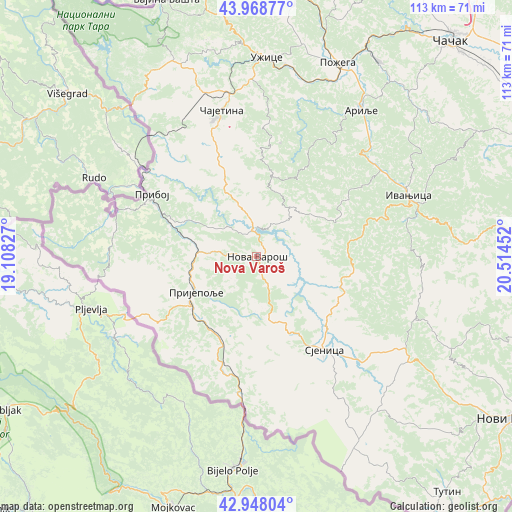
Nova Varoš GPS coordinates[2]
43° 27' 38.016" North, 19° 48' 41.004" East
| Map corner | latitude | longitude |
|---|---|---|
| Upper-left | 43.96877°, | 19.10827° |
| Center: | 43.46056°, | 19.81139° |
| Lower-right: | 42.94804°, | 20.51452° |
| Map W x H: | 113.5×113.5 km | = 70.5×70.5mi |
| max Lat: | 46.1° ⇑86.8% North |
| Nova Varoš: | 43.46056° |
| min Lat: | ⇓13.2% South 42.25846° |
| min Long | Nova Varoš | max Long |
| 18.9276° | 19.81139° | 22.77556° |
| W 27%⇐ | ⇒73% E |
Elevation
Elevation of Nova Varoš is 987 m = 3238 ft, and this is 810.6 m = 2659 ft above average elevation for this country.
| Max E: |
1421 m = 4662 ft | 1.4% |
| Nova Varoš | 987 m 3238 ft | |
| Avg. | 176.4 m = 579 ft | |
Min E: |
49 m = 161 ft | 98.6% |
See also: Serbia elevation on elevation.city.
Geographical zone
Nova Varoš is located in North temperate zone (between Tropic of Cancer and the Arctic Circle). Distance of this Northern Tropic circle is 2226.4 km =1383.4 mi to South.| Distance of | km | miles | from Nova Varoš |
|---|---|---|---|
| North Pole | 5174.7 | 3215.4 | to North |
| Arctic Circle | 2568.8 | 1596.2 | to North |
| Tropic Cancer | 2226.4 | 1383.4 | to South |
| Equator | 4832.4 | 3002.7 | to South |


Nearby cities:
15 places around Nova Varoš: (largest is in red/bold)
• Arilje
39.8 km =24.7 mi,  35°
35°
• Ivanjica
36.4 km =22.6 mi,  68°
68°
• Lučani
51.7 km =32.1 mi,  30°
30°
• Mokra Gora
44.2 km =27.5 mi,  325°
325°
• Osječenik
35.3 km =21.9 mi,  173°
173°
• Požega
46.8 km =29.1 mi,  22°
22°
• Priboj
26.8 km =16.7 mi,  300°
300°
• Prijepolje
15.3 km =9.5 mi,  239°
239°
• Sjenica
25.8 km =16 mi,  143°
143°
• Sokolovica
49.1 km =30.5 mi,  123°
123°
• Sokolovo Brdo
36 km =22.4 mi,  180°
180°
• Užice
44.4 km =27.6 mi,  3°
3°
• Zlatibor
31.2 km =19.4 mi,  343°
343°
• Ðurići
51.7 km =32.1 mi,  321°
321°
• Čajetina
33.1 km =20.6 mi,  346°
346°
Sources, notices
• [Note1] Compared only with cities in Serbia existing in our database
• [Src1] Map data: © OpenStreetMap contributors (CC-BY-SA)
• [Src2] Other city data from geonames.org with taken over terms of usage.
• [Src3] Geographical zone / Annual Mean Temperature by Robert A. Rohde @ Wikipedia
