Sjenica geodata
Sjenica (Central Serbia) is a seat of a third-order administrative division; located in Serbia in Europe/Belgrade (GMT+2) time zone. In our database, there are 365 cities with bigger population. Compared to other cities in Serbia, 89.1% of cities are located further ↑North; 68.7% of cities are located further →East and 99.1% of cities have lower elevation than Sjenica. Note1


Sjenica GPS coordinates[2]
43° 16' 23.016" North, 19° 59' 57.984" East
| Map corner | latitude | longitude |
|---|---|---|
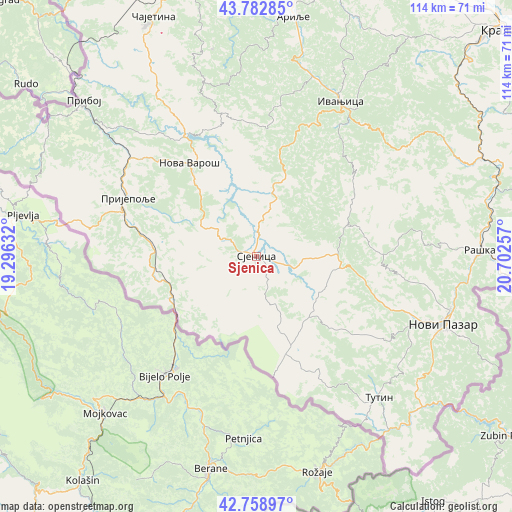
| Upper-left | 43.78285°, | 19.29632° |
| Center: | 43.27306°, | 19.99944° |
| Lower-right: | 42.75897°, | 20.70257° |
| Map W x H: | 113.8×113.8 km | = 70.7×70.7mi |
| max Lat: | 46.1° ⇑89.1% North |
| Sjenica: | 43.27306° |
| min Lat: | ⇓10.9% South 42.25846° |
| min Long | Sjenica | max Long |
| 18.9276° | 19.99944° | 22.77556° |
| W 31.3%⇐ | ⇒68.7% E |
Elevation
Elevation of Sjenica is 1011 m = 3317 ft, and this is 834.6 m = 2738 ft above average elevation for this country.
| Max E: |
1421 m = 4662 ft | 0.90000000000001% |
| Sjenica | 1011 m 3317 ft | |
| Avg. | 176.4 m = 579 ft | |
Min E: |
49 m = 161 ft | 99.1% |
See also: Serbia elevation on elevation.city.
Geographical zone
Sjenica is located in North temperate zone (between Tropic of Cancer and the Arctic Circle). Distance of this Northern Tropic circle is 2205.6 km =1370.5 mi to South.| Distance of | km | miles | from Sjenica |
|---|---|---|---|
| North Pole | 5195.5 | 3228.3 | to North |
| Arctic Circle | 2589.7 | 1609.2 | to North |
| Tropic Cancer | 2205.6 | 1370.5 | to South |
| Equator | 4811.5 | 2989.7 | to South |


Nearby cities:
15 places around Sjenica: (largest is in red/bold)
• Arilje
53.9 km =33.5 mi,  8°
8°
• Brezovica
62.4 km =38.8 mi,  32°
32°
• Ivanjica
38.9 km =24.2 mi, 28°
• Nova Varoš
25.8 km =16 mi,  323°
323°
• Novi Pazar
44.2 km =27.5 mi,  110°
110°
• Osječenik
18.2 km =11.3 mi,  218°
218°
• Požega
64.1 km =39.8 mi,  2°
2°
• Priboj
51.5 km =32 mi,  311°
311°
• Prijepolje
31.2 km =19.4 mi,  294°
294°
• Raška
49.9 km =31 mi,  88°
88°
• Sokolovica
26.4 km =16.4 mi,  104°
104°
• Sokolovo Brdo
21.8 km =13.5 mi,  226°
226°
• Tutin
41.4 km =25.7 mi,  139°
139°
• Zlatibor
56.1 km =34.9 mi,  334°
334°
• Čajetina
57.8 km =35.9 mi,  336°
336°
Sources, notices
• [Note1] Compared only with cities in Serbia existing in our database
• [Src1] Map data: © OpenStreetMap contributors (CC-BY-SA)
• [Src2] Other city data from geonames.org with taken over terms of usage.
• [Src3] Geographical zone / Annual Mean Temperature by Robert A. Rohde @ Wikipedia
