Kamenka geodata
Kamenka (Primorskiy (Maritime) Kray) is a populated place; located in Russia in Asia/Vladivostok (GMT+10) time zone. With population of 1,693 people, there are 4301 cities with bigger population in this country. Compared to other cities in Russia, 89.5% of cities are located further ↑North; 97.3% of cities are located further ←West and 96.4% of cities have higher elevation than Kamenka. Note1


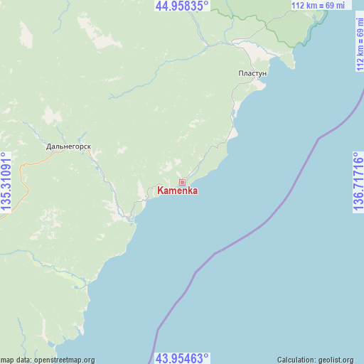
Kamenka GPS coordinates[2]
44° 27' 31.14" North, 136° 0' 50.508" East
| Map corner | latitude | longitude |
|---|---|---|
| Upper-left | 44.95835°, | 135.31091° |
| Center: | 44.45865°, | 136.01403° |
| Lower-right: | 43.95463°, | 136.71716° |
| Map W x H: | 111.6×111.6 km | = 69.3×69.3mi |
| max Lat: | 73.50819° ⇑89.5% North |
| Kamenka: | 44.45865° |
| min Lat: | ⇓10.5% South 41.28413° |
| min Long | Kamenka | max Long |
| -179.12198° | 136.01403° | 179.35046° |
| W 97.3%⇐ | ⇒2.7% E |
Elevation
Elevation of Kamenka is 9 m = 30 ft, and this is 193.6 m = 635 ft below average elevation for this country.
| Max E: |
2518 m = 8261 ft | 96.4% |
| Avg. | 202.6 m = 665 ft | |
| Kamenka | 9 m = 30 ft | |
Min E: |
-28 m = -92 ft | 3.6% |
See also: Russia elevation on elevation.city.
Geographical zone
Kamenka is located in North temperate zone (between Tropic of Cancer and the Arctic Circle). Distance of this Northern Tropic circle is 2337.4 km =1452.4 mi to South.| Distance of | km | miles | from Kamenka |
|---|---|---|---|
| North Pole | 5063.7 | 3146.4 | to North |
| Arctic Circle | 2457.8 | 1527.2 | to North |
| Tropic Cancer | 2337.4 | 1452.4 | to South |
| Equator | 4943.3 | 3071.6 | to South |


Nearby cities:
15 places around Kamenka: (largest is in red/bold)
• Chuguyevka
174 km =108.1 mi,  259°
259°
• Dalnegorsk
33.1 km =20.6 mi,  289°
289°
• Dostoyevka
201.8 km =125.4 mi,  265°
265°
• Gornorechenskiy
74.6 km =46.4 mi,  253°
253°
• Kavalerovo
79.2 km =49.2 mi, 254°
• Kirovskiy
210.5 km =130.8 mi, 289°
• Krasnorechenskiy
55.7 km =34.6 mi, 289°
• Lazo
206.7 km =128.4 mi,  234°
234°
• Novopokrovka
195.2 km =121.3 mi,  322°
322°
• Ol’ga
97.9 km =60.8 mi,  216°
216°
• Plastun
39.7 km =24.7 mi,  32°
32°
• Rudnaya Pristan’
19.4 km =12.1 mi, 234°
• Rudnyy
86.1 km =53.5 mi, 256°
• Terney
81.1 km =50.4 mi,  35°
35°
• Yakovlevka
201.7 km =125.3 mi, 268°
Sources, notices
• [Note1] Compared only with cities in Russia existing in our database
• [Src1] Map data: © OpenStreetMap contributors (CC-BY-SA)
• [Src2] Other city data from geonames.org with taken over terms of usage.
• [Src3] Geographical zone / Annual Mean Temperature by Robert A. Rohde @ Wikipedia
