Yuzhno-Sukhokumsk geodata
Yuzhno-Sukhokumsk (Dagestan) is a populated place; located in Russia in Europe/Moscow (GMT+3) time zone. With population of 10,665 people, there are 1414 cities with bigger population in this country. Compared to other cities in Russia, 88.9% of cities are located further ↑North; 51.8% of cities are located further ←West and 95.9% of cities have higher elevation than Yuzhno-Sukhokumsk. Note1


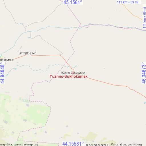
Yuzhno-Sukhokumsk GPS coordinates[2]
44° 39' 29.196" North, 45° 38' 36.96" East
| Map corner | latitude | longitude |
|---|---|---|
| Upper-left | 45.1561°, | 44.94048° |
| Center: | 44.65811°, | 45.6436° |
| Lower-right: | 44.15581°, | 46.34673° |
| Map W x H: | 111.2×111.2 km | = 69.1×69.1mi |
| max Lat: | 73.50819° ⇑88.9% North |
| Yuzhno-Sukhokumsk: | 44.65811° |
| min Lat: | ⇓11.1% South 41.28413° |
| min Long | Yuzhno-Sukhokum | max Long |
| -179.12198° | 45.6436° | 179.35046° |
| W 51.8%⇐ | ⇒48.2% E |
Elevation
Elevation of Yuzhno-Sukhokumsk is 10 m = 33 ft, and this is 192.6 m = 632 ft below average elevation for this country.
| Max E: |
2518 m = 8261 ft | 95.9% |
| Avg. | 202.6 m = 665 ft | |
| Yuzhno-Sukhokumsk | 10 m = 33 ft | |
Min E: |
-28 m = -92 ft | 4.1% |
See also: Russia elevation on elevation.city.
Geographical zone
Yuzhno-Sukhokumsk is located in North temperate zone (between Tropic of Cancer and the Arctic Circle). Distance of this Northern Tropic circle is 2359.6 km =1466.2 mi to South.| Distance of | km | miles | from Yuzhno-Sukhokumsk |
|---|---|---|---|
| North Pole | 5041.5 | 3132.6 | to North |
| Arctic Circle | 2435.7 | 1513.5 | to North |
| Tropic Cancer | 2359.6 | 1466.2 | to South |
| Equator | 4965.5 | 3085.4 | to South |


Nearby cities:
15 places around Yuzhno-Sukhokumsk: (largest is in red/bold)
• Achikulak
64.9 km =40.3 mi,  259°
259°
• Irgakly
77.8 km =48.3 mi,  244°
244°
• Kara-Tyube
16.6 km =10.3 mi, 260°
• Kayasula
63.1 km =39.2 mi,  234°
234°
• Kochubey
80.3 km =49.9 mi,  112°
112°
• Komsomol’skiy
81 km =50.3 mi,  22°
22°
• Levokumskoye
79.7 km =49.5 mi,  283°
283°
• Nadezhda
103.6 km =64.4 mi, 233°
• Neftekumsk
52.6 km =32.7 mi, 281°
• Pravokumskoye
79.7 km =49.5 mi, 278°
• Stepnoye
94.4 km =58.7 mi, 242°
• Tarumovka
96 km =59.7 mi,  132°
132°
• Terekli-Mekteb
57.5 km =35.7 mi,  161°
161°
• Urozhaynoye
58.8 km =36.5 mi, 284°
• Zaterechnyy
37.4 km =23.2 mi,  293°
293°
In other languages:
- In France: Ioujno-Soukhokoumsk
- In German: Juschno-Suchokumsk
- In Italian: Južno-Suchokumsk
- In Russian: Южно-Сухокумск
- In Chinese: 南蘇霍庫姆斯克
Sources, notices
• [Note1] Compared only with cities in Russia existing in our database
• [Src1] Map data: © OpenStreetMap contributors (CC-BY-SA)
• [Src2] Other city data from geonames.org with taken over terms of usage.
• [Src3] Geographical zone / Annual Mean Temperature by Robert A. Rohde @ Wikipedia
