Verkhovazh’ye geodata
Verkhovazh’ye (Vologda) is a populated place; located in Russia in Europe/Moscow (GMT+3) time zone. With population of 5,200 people, there are 2561 cities with bigger population in this country. Compared to other cities in Russia, 92.5% of cities are located further ↓South; 59.4% of cities are located further →East and 76.9% of cities have higher elevation than Verkhovazh’ye. Note1


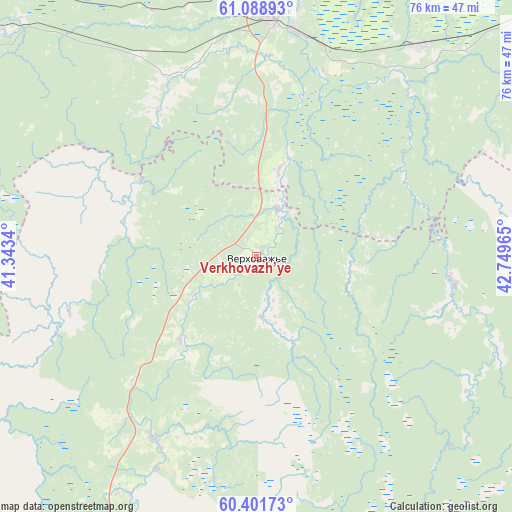
Verkhovazh’ye GPS coordinates[2]
60° 44' 49.812" North, 42° 2' 47.472" East
| Map corner | latitude | longitude |
|---|---|---|
| Upper-left | 61.08893°, | 41.3434° |
| Center: | 60.74717°, | 42.04652° |
| Lower-right: | 60.40173°, | 42.74965° |
| Map W x H: | 76.4×76.4 km | = 47.5×47.5mi |
| max Lat: | 73.50819° ⇑7.5% North |
| Verkhovazh’ye: | 60.74717° |
| min Lat: | ⇓92.5% South 41.28413° |
| min Long | Verkhovazh’ye | max Long |
| -179.12198° | 42.04652° | 179.35046° |
| W 40.6%⇐ | ⇒59.4% E |
Elevation
Elevation of Verkhovazh’ye is 81 m = 266 ft, and this is 121.6 m = 399 ft below average elevation for this country.
| Max E: |
2518 m = 8261 ft | 76.9% |
| Avg. | 202.6 m = 665 ft | |
| Verkhovazh’ye | 81 m = 266 ft | |
Min E: |
-28 m = -92 ft | 23.1% |
See also: Russia elevation on elevation.city.
Geographical zone
Verkhovazh’ye is located in North temperate zone (between Tropic of Cancer and the Arctic Circle). Distance of this North polar circle is 646.7 km =401.8 mi to North.| Distance of | km | miles | from Verkhovazh’ye |
|---|---|---|---|
| North Pole | 3252.6 | 2021.1 | to North |
| Arctic Circle | 646.7 | 401.8 | to North |
| Tropic Cancer | 4148.5 | 2577.8 | to South |
| Equator | 6754.5 | 4197.1 | to South |


Nearby cities:
15 places around Verkhovazh’ye: (largest is in red/bold)
• Berëznik
100.9 km =62.7 mi,  57°
57°
• Ileza
105.9 km =65.8 mi,  71°
71°
• Konosha
100.1 km =62.2 mi,  284°
284°
• Kuloy
39.7 km =24.7 mi,  37°
37°
• Podyuga
74.7 km =46.4 mi,  301°
301°
• Shangaly
81.5 km =50.6 mi, 58°
• Solginskiy
50.8 km =31.6 mi,  311°
311°
• Syamzha
97.7 km =60.7 mi,  213°
213°
• Tarnogskiy Gorodok
87.8 km =54.6 mi,  108°
108°
• Tot’ma
94.6 km =58.8 mi,  155°
155°
• Ust’-Shonosha
59 km =36.7 mi,  319°
319°
• Vel’sk
36 km =22.4 mi,  4°
4°
• Voloshka
123.9 km =77 mi, 301°
• Vozhega
104.2 km =64.7 mi,  252°
252°
• Yertsevo
106.6 km =66.2 mi,  272°
272°
Sources, notices
• [Note1] Compared only with cities in Russia existing in our database
• [Src1] Map data: © OpenStreetMap contributors (CC-BY-SA)
• [Src2] Other city data from geonames.org with taken over terms of usage.
• [Src3] Geographical zone / Annual Mean Temperature by Robert A. Rohde @ Wikipedia
