Vel’sk geodata
Vel’sk (Arkhangelskaya) is a populated place; located in Russia in Europe/Moscow (GMT+3) time zone. With population of 23,126 people, there are 788 cities with bigger population in this country. Compared to other cities in Russia, 93% of cities are located further ↓South; 59.3% of cities are located further →East and 72.9% of cities have higher elevation than Vel’sk. Note1


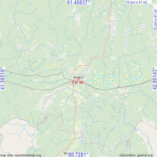
Vel’sk GPS coordinates[2]
61° 4' 12.216" North, 42° 5' 53.88" East
| Map corner | latitude | longitude |
|---|---|---|
| Upper-left | 61.40837°, | 41.39518° |
| Center: | 61.07006°, | 42.0983° |
| Lower-right: | 60.7281°, | 42.80143° |
| Map W x H: | 75.6×75.6 km | = 47×47mi |
| max Lat: | 73.50819° ⇑7% North |
| Vel’sk: | 61.07006° |
| min Lat: | ⇓93% South 41.28413° |
| min Long | Vel’sk | max Long |
| -179.12198° | 42.0983° | 179.35046° |
| W 40.7%⇐ | ⇒59.3% E |
Elevation
Elevation of Vel’sk is 94 m = 308 ft, and this is 108.6 m = 356 ft below average elevation for this country.
| Max E: |
2518 m = 8261 ft | 72.9% |
| Avg. | 202.6 m = 665 ft | |
| Vel’sk | 94 m = 308 ft | |
Min E: |
-28 m = -92 ft | 27.1% |
See also: Russia elevation on elevation.city.
Geographical zone
Vel’sk is located in North temperate zone (between Tropic of Cancer and the Arctic Circle). Distance of this North polar circle is 610.8 km =379.5 mi to North.| Distance of | km | miles | from Vel’sk |
|---|---|---|---|
| North Pole | 3216.7 | 1998.8 | to North |
| Arctic Circle | 610.8 | 379.5 | to North |
| Tropic Cancer | 4184.4 | 2600.1 | to South |
| Equator | 6790.4 | 4219.4 | to South |


Nearby cities:
15 places around Vel’sk: (largest is in red/bold)
• Berëznik
83.8 km =52.1 mi,  77°
77°
• Ileza
97 km =60.3 mi,  91°
91°
• Konosha
99.8 km =62 mi,  263°
263°
• Kuloy
21.7 km =13.5 mi,  101°
101°
• Nyandoma
120.8 km =75.1 mi,  303°
303°
• Podyuga
66.4 km =41.3 mi,  272°
272°
• Shangaly
66.7 km =41.4 mi, 84°
• Shenkursk
123 km =76.4 mi,  20°
20°
• Solginskiy
40.7 km =25.3 mi, 266°
• Tarnogskiy Gorodok
102.2 km =63.5 mi,  128°
128°
• Ust’-Shonosha
41.6 km =25.8 mi,  282°
282°
• Verkhovazh’ye
36 km =22.4 mi,  184°
184°
• Voloshka
111.6 km =69.3 mi,  285°
285°
• Vozhega
121.6 km =75.6 mi,  236°
236°
• Yertsevo
112.9 km =70.2 mi,  254°
254°
Sources, notices
• [Note1] Compared only with cities in Russia existing in our database
• [Src1] Map data: © OpenStreetMap contributors (CC-BY-SA)
• [Src2] Other city data from geonames.org with taken over terms of usage.
• [Src3] Geographical zone / Annual Mean Temperature by Robert A. Rohde @ Wikipedia
