Shangaly geodata
Shangaly (Arkhangelskaya) is a populated place; located in Russia in Europe/Moscow (GMT+3) time zone. With population of 2,164 people, there are 4089 cities with bigger population in this country. Compared to other cities in Russia, 93.3% of cities are located further ↓South; 55.3% of cities are located further →East and 82% of cities have higher elevation than Shangaly. Note1


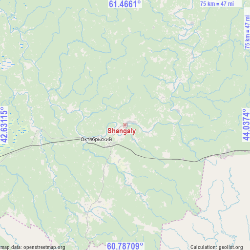
Shangaly GPS coordinates[2]
61° 7' 42.312" North, 43° 20' 3.372" East
| Map corner | latitude | longitude |
|---|---|---|
| Upper-left | 61.4661°, | 42.63115° |
| Center: | 61.12842°, | 43.33427° |
| Lower-right: | 60.78709°, | 44.0374° |
| Map W x H: | 75.5×75.5 km | = 46.9×46.9mi |
| max Lat: | 73.50819° ⇑6.7% North |
| Shangaly: | 61.12842° |
| min Lat: | ⇓93.3% South 41.28413° |
| min Long | Shangaly | max Long |
| -179.12198° | 43.33427° | 179.35046° |
| W 44.7%⇐ | ⇒55.3% E |
Elevation
Elevation of Shangaly is 63 m = 207 ft, and this is 139.6 m = 458 ft below average elevation for this country.
| Max E: |
2518 m = 8261 ft | 82% |
| Avg. | 202.6 m = 665 ft | |
| Shangaly | 63 m = 207 ft | |
Min E: |
-28 m = -92 ft | 18% |
See also: Russia elevation on elevation.city.
Geographical zone
Shangaly is located in North temperate zone (between Tropic of Cancer and the Arctic Circle). Distance of this North polar circle is 604.3 km =375.5 mi to North.| Distance of | km | miles | from Shangaly |
|---|---|---|---|
| North Pole | 3210.2 | 1994.7 | to North |
| Arctic Circle | 604.3 | 375.5 | to North |
| Tropic Cancer | 4190.9 | 2604.1 | to South |
| Equator | 6796.8 | 4223.3 | to South |


Nearby cities:
15 places around Shangaly: (largest is in red/bold)
• Berëznik
19.5 km =12.1 mi,  52°
52°
• Ileza
31.5 km =19.6 mi,  105°
105°
• Kizema
80.3 km =49.9 mi,  91°
91°
• Kuloy
46.6 km =29 mi,  256°
256°
• Loyga
68.6 km =42.6 mi, 94°
• Mirnyy
68.2 km =42.4 mi,  70°
70°
• Nyuksenitsa
93.5 km =58.1 mi,  148°
148°
• Podyuga
132.7 km =82.5 mi,  268°
268°
• Shenkursk
111.5 km =69.3 mi,  348°
348°
• Solginskiy
107.4 km =66.7 mi, 265°
• Tarnogskiy Gorodok
71.1 km =44.2 mi,  169°
169°
• Tot’ma
132.1 km =82.1 mi,  193°
193°
• Ust’-Shonosha
106.9 km =66.4 mi, 271°
• Vel’sk
66.7 km =41.4 mi, 264°
• Verkhovazh’ye
81.5 km =50.6 mi,  238°
238°
Sources, notices
• [Note1] Compared only with cities in Russia existing in our database
• [Src1] Map data: © OpenStreetMap contributors (CC-BY-SA)
• [Src2] Other city data from geonames.org with taken over terms of usage.
• [Src3] Geographical zone / Annual Mean Temperature by Robert A. Rohde @ Wikipedia
