Verkhnyaya Tishanka geodata
Verkhnyaya Tishanka (Voronezj) is a populated place; located in Russia in Europe/Moscow (GMT+3) time zone. With population of 3,602 people, there are 3336 cities with bigger population in this country. Compared to other cities in Russia, 73.4% of cities are located further ↑North; 64.8% of cities are located further →East and 69.3% of cities have higher elevation than Verkhnyaya Tishanka. Note1


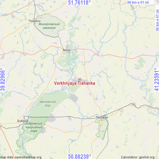
Verkhnyaya Tishanka GPS coordinates[2]
51° 19' 26.004" North, 40° 31' 58.008" East
| Map corner | latitude | longitude |
|---|---|---|
| Upper-left | 51.76118°, | 39.82966° |
| Center: | 51.32389°, | 40.53278° |
| Lower-right: | 50.88239°, | 41.23591° |
| Map W x H: | 97.7×97.7 km | = 60.7×60.7mi |
| max Lat: | 73.50819° ⇑73.4% North |
| Verkhnyaya Tishanka: | 51.32389° |
| min Lat: | ⇓26.6% South 41.28413° |
| min Long | Verkhnyaya Tish | max Long |
| -179.12198° | 40.53278° | 179.35046° |
| W 35.2%⇐ | ⇒64.8% E |
Elevation
Elevation of Verkhnyaya Tishanka is 104 m = 341 ft, and this is 98.6 m = 323 ft below average elevation for this country.
| Max E: |
2518 m = 8261 ft | 69.3% |
| Avg. | 202.6 m = 665 ft | |
| Verkhnyaya Tishanka | 104 m = 341 ft | |
Min E: |
-28 m = -92 ft | 30.7% |
See also: Russia elevation on elevation.city.
Geographical zone
Verkhnyaya Tishanka is located in North temperate zone (between Tropic of Cancer and the Arctic Circle). Distance of this North polar circle is 1694.5 km =1052.9 mi to North.| Distance of | km | miles | from Verkhnyaya Tishanka |
|---|---|---|---|
| North Pole | 4300.4 | 2672.1 | to North |
| Arctic Circle | 1694.5 | 1052.9 | to North |
| Tropic Cancer | 3100.8 | 1926.7 | to South |
| Equator | 5706.7 | 3546 | to South |


Nearby cities:
15 places around Verkhnyaya Tishanka: (largest is in red/bold)
• Abramovka
37.1 km =23.1 mi,  113°
113°
• Anna
19.2 km =11.9 mi,  338°
338°
• Bobrov
43 km =26.7 mi,  233°
233°
• Buturlinovka
55.9 km =34.7 mi,  174°
174°
• Khrenovoye
28.3 km =17.6 mi,  216°
216°
• Kozlovka
51.6 km =32.1 mi,  185°
185°
• Novaya Chigla
11.8 km =7.3 mi,  198°
198°
• Panino
45.3 km =28.1 mi,  322°
322°
• Pereleshino
53.5 km =33.2 mi,  329°
329°
• Pereleshinskiy
49.3 km =30.6 mi, 331°
• Sadovoye
23.1 km =14.4 mi,  354°
354°
• Sloboda
25.8 km =16 mi, 218°
• Talovaya
27 km =16.8 mi,  149°
149°
• Yelan’-Koleno
52.2 km =32.4 mi, 111°
• Yelan’-Kolenovskiy
46.6 km =29 mi, 112°
Sources, notices
• [Note1] Compared only with cities in Russia existing in our database
• [Src1] Map data: © OpenStreetMap contributors (CC-BY-SA)
• [Src2] Other city data from geonames.org with taken over terms of usage.
• [Src3] Geographical zone / Annual Mean Temperature by Robert A. Rohde @ Wikipedia
