Anna geodata
Anna (Voronezj) is a populated place; located in Russia in Europe/Moscow (GMT+3) time zone. With population of 19,148 people, there are 908 cities with bigger population in this country. Compared to other cities in Russia, 72.6% of cities are located further ↑North; 65.4% of cities are located further →East and 51.5% of cities have lower elevation than Anna. Note1


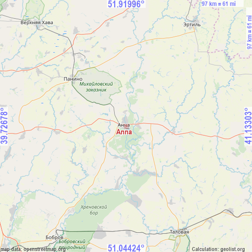
Anna GPS coordinates[2]
51° 29' 3.12" North, 40° 25' 47.64" East
| Map corner | latitude | longitude |
|---|---|---|
| Upper-left | 51.91996°, | 39.72678° |
| Center: | 51.4842°, | 40.4299° |
| Lower-right: | 51.04424°, | 41.13303° |
| Map W x H: | 97.4×97.4 km | = 60.5×60.5mi |
| max Lat: | 73.50819° ⇑72.6% North |
| Anna: | 51.4842° |
| min Lat: | ⇓27.4% South 41.28413° |
| min Long | Anna | max Long |
| -179.12198° | 40.4299° | 179.35046° |
| W 34.6%⇐ | ⇒65.4% E |
Elevation
Elevation of Anna is 148 m = 486 ft, and this is 54.6 m = 179 ft below average elevation for this country.
| Max E: |
2518 m = 8261 ft | 48.5% |
| Avg. | 202.6 m = 665 ft | |
| Anna | 148 m = 486 ft | |
Min E: |
-28 m = -92 ft | 51.5% |
See also: Russia elevation on elevation.city.
Geographical zone
Anna is located in North temperate zone (between Tropic of Cancer and the Arctic Circle). Distance of this North polar circle is 1676.7 km =1041.9 mi to North.| Distance of | km | miles | from Anna |
|---|---|---|---|
| North Pole | 4282.6 | 2661.1 | to North |
| Arctic Circle | 1676.7 | 1041.9 | to North |
| Tropic Cancer | 3118.6 | 1937.8 | to South |
| Equator | 5724.5 | 3557 | to South |


Nearby cities:
15 places around Anna: (largest is in red/bold)
• Abramovka
52.6 km =32.7 mi,  128°
128°
• Bobrov
51.2 km =31.8 mi,  212°
212°
• Ertil’
47.3 km =29.4 mi,  33°
33°
• Kashirskoye
57.1 km =35.5 mi,  262°
262°
• Khrenovoye
41.7 km =25.9 mi,  193°
193°
• Novaya Chigla
29.2 km =18.1 mi,  173°
173°
• Panino
27.3 km =17 mi,  311°
311°
• Pereleshino
34.6 km =21.5 mi,  324°
324°
• Pereleshinskiy
30.3 km =18.8 mi,  327°
327°
• Sadovoye
7.2 km =4.5 mi,  43°
43°
• Sloboda
39.1 km =24.3 mi, 193°
• Talovaya
46.1 km =28.6 mi,  153°
153°
• Verkhnyaya Khava
52 km =32.3 mi, 319°
• Verkhnyaya Tishanka
19.2 km =11.9 mi,  158°
158°
• Yelan’-Kolenovskiy
61.5 km =38.2 mi, 125°
Sources, notices
• [Note1] Compared only with cities in Russia existing in our database
• [Src1] Map data: © OpenStreetMap contributors (CC-BY-SA)
• [Src2] Other city data from geonames.org with taken over terms of usage.
• [Src3] Geographical zone / Annual Mean Temperature by Robert A. Rohde @ Wikipedia
