Nyuksenitsa geodata
Nyuksenitsa (Vologda) is a populated place; located in Russia in Europe/Moscow (GMT+3) time zone. With population of 4,322 people, there are 2944 cities with bigger population in this country. Compared to other cities in Russia, 92% of cities are located further ↓South; 52.1% of cities are located further →East and 67.7% of cities have higher elevation than Nyuksenitsa. Note1


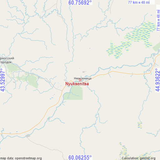
Nyuksenitsa GPS coordinates[2]
60° 24' 41.724" North, 44° 13' 59.124" East
| Map corner | latitude | longitude |
|---|---|---|
| Upper-left | 60.75692°, | 43.52997° |
| Center: | 60.41159°, | 44.23309° |
| Lower-right: | 60.06255°, | 44.93622° |
| Map W x H: | 77.2×77.2 km | = 48×48mi |
| max Lat: | 73.50819° ⇑8% North |
| Nyuksenitsa: | 60.41159° |
| min Lat: | ⇓92% South 41.28413° |
| min Long | Nyuksenitsa | max Long |
| -179.12198° | 44.23309° | 179.35046° |
| W 47.9%⇐ | ⇒52.1% E |
Elevation
Elevation of Nyuksenitsa is 108 m = 354 ft, and this is 94.6 m = 310 ft below average elevation for this country.
| Max E: |
2518 m = 8261 ft | 67.7% |
| Avg. | 202.6 m = 665 ft | |
| Nyuksenitsa | 108 m = 354 ft | |
Min E: |
-28 m = -92 ft | 32.3% |
See also: Russia elevation on elevation.city.
Geographical zone
Nyuksenitsa is located in North temperate zone (between Tropic of Cancer and the Arctic Circle). Distance of this North polar circle is 684 km =425 mi to North.| Distance of | km | miles | from Nyuksenitsa |
|---|---|---|---|
| North Pole | 3289.9 | 2044.2 | to North |
| Arctic Circle | 684 | 425 | to North |
| Tropic Cancer | 4111.2 | 2554.6 | to South |
| Equator | 6717.1 | 4173.8 | to South |


Nearby cities:
15 places around Nyuksenitsa: (largest is in red/bold)
• Berëznik
97.4 km =60.5 mi,  340°
340°
• Ileza
73.6 km =45.7 mi,  345°
345°
• Imeni Babushkina
95.1 km =59.1 mi,  220°
220°
• Kichmengskiy Gorodok
98.2 km =61 mi,  119°
119°
• Kizema
84.5 km =52.5 mi,  22°
22°
• Kuloy
117 km =72.7 mi,  306°
306°
• Loyga
76.9 km =47.8 mi, 15°
• Mirnyy
103.7 km =64.4 mi,  9°
9°
• Nikol’sk
118.9 km =73.9 mi,  145°
145°
• Shangaly
93.5 km =58.1 mi,  328°
328°
• Tarnogskiy Gorodok
37.3 km =23.2 mi,  285°
285°
• Tot’ma
94.6 km =58.8 mi,  239°
239°
• Udimskiy
122.1 km =75.9 mi,  48°
48°
• Velikiy Ustyug
120.1 km =74.6 mi,  71°
71°
• Verkhovazh’ye
125.1 km =77.7 mi, 287°
Sources, notices
• [Note1] Compared only with cities in Russia existing in our database
• [Src1] Map data: © OpenStreetMap contributors (CC-BY-SA)
• [Src2] Other city data from geonames.org with taken over terms of usage.
• [Src3] Geographical zone / Annual Mean Temperature by Robert A. Rohde @ Wikipedia
