Sarmanovo geodata
Sarmanovo (Tatarstan Republic) is a populated place; located in Russia in Europe/Moscow (GMT+3) time zone. With population of 6,339 people, there are 2169 cities with bigger population in this country. Compared to other cities in Russia, 55.8% of cities are located further ↓South; 64.6% of cities are located further ←West and 57.3% of cities have higher elevation than Sarmanovo. Note1


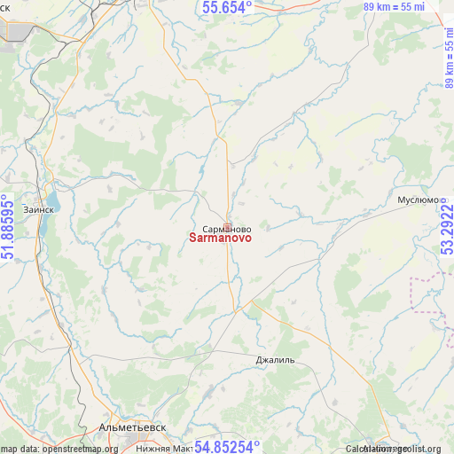
Sarmanovo GPS coordinates[2]
55° 15' 19.044" North, 52° 35' 20.652" East
| Map corner | latitude | longitude |
|---|---|---|
| Upper-left | 55.654°, | 51.88595° |
| Center: | 55.25529°, | 52.58907° |
| Lower-right: | 54.85254°, | 53.2922° |
| Map W x H: | 89.1×89.1 km | = 55.4×55.4mi |
| max Lat: | 73.50819° ⇑44.2% North |
| Sarmanovo: | 55.25529° |
| min Lat: | ⇓55.8% South 41.28413° |
| min Long | Sarmanovo | max Long |
| -179.12198° | 52.58907° | 179.35046° |
| W 64.6%⇐ | ⇒35.4% E |
Elevation
Elevation of Sarmanovo is 130 m = 427 ft, and this is 72.6 m = 238 ft below average elevation for this country.
| Max E: |
2518 m = 8261 ft | 57.3% |
| Avg. | 202.6 m = 665 ft | |
| Sarmanovo | 130 m = 427 ft | |
Min E: |
-28 m = -92 ft | 42.7% |
See also: Russia elevation on elevation.city.
Geographical zone
Sarmanovo is located in North temperate zone (between Tropic of Cancer and the Arctic Circle). Distance of this North polar circle is 1257.4 km =781.3 mi to North.| Distance of | km | miles | from Sarmanovo |
|---|---|---|---|
| North Pole | 3863.2 | 2400.5 | to North |
| Arctic Circle | 1257.4 | 781.3 | to North |
| Tropic Cancer | 3537.9 | 2198.3 | to South |
| Equator | 6143.8 | 3817.6 | to South |


Nearby cities:
15 places around Sarmanovo: (largest is in red/bold)
• Aktyubinskiy
51 km =31.7 mi,  164°
164°
• Al’met’yevsk
42.7 km =26.5 mi,  204°
204°
• Bakaly
77.5 km =48.2 mi,  96°
96°
• Dzhalil’
27.4 km =17 mi, 160°
• Karabash
62.5 km =38.8 mi,  180°
180°
• Leninogorsk
73 km =45.4 mi,  186°
186°
• Mendeleyevsk
75 km =46.6 mi,  345°
345°
• Menzelinsk
61.6 km =38.3 mi,  31°
31°
• Muslyumovo
38.7 km =24 mi,  82°
82°
• Naberezhnyye Chelny
53.5 km =33.2 mi, 347°
• Nizhnekamsk
64.2 km =39.9 mi,  311°
311°
• Nizhnyaya Maktama
44.7 km =27.8 mi, 193°
• Russkiy Aktash
38.3 km =23.8 mi,  230°
230°
• Yelabuga
65.2 km =40.5 mi,  329°
329°
• Zainsk
33.7 km =20.9 mi,  282°
282°
Sources, notices
• [Note1] Compared only with cities in Russia existing in our database
• [Src1] Map data: © OpenStreetMap contributors (CC-BY-SA)
• [Src2] Other city data from geonames.org with taken over terms of usage.
• [Src3] Geographical zone / Annual Mean Temperature by Robert A. Rohde @ Wikipedia
