Leninogorsk geodata
Leninogorsk (Tatarstan Republic) is a populated place; located in Russia in Europe/Moscow (GMT+3) time zone. With population of 66,263 people, there are 309 cities with bigger population in this country. Compared to other cities in Russia, 50.3% of cities are located further ↑North; 64.4% of cities are located further ←West and 76.4% of cities have lower elevation than Leninogorsk. Note1


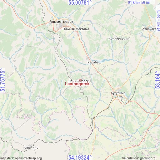
Leninogorsk GPS coordinates[2]
54° 36' 9.216" North, 52° 27' 39.132" East
| Map corner | latitude | longitude |
|---|---|---|
| Upper-left | 55.00781°, | 51.75775° |
| Center: | 54.60256°, | 52.46087° |
| Lower-right: | 54.19324°, | 53.164° |
| Map W x H: | 90.6×90.6 km | = 56.3×56.3mi |
| max Lat: | 73.50819° ⇑50.3% North |
| Leninogorsk: | 54.60256° |
| min Lat: | ⇓49.7% South 41.28413° |
| min Long | Leninogorsk | max Long |
| -179.12198° | 52.46087° | 179.35046° |
| W 64.4%⇐ | ⇒35.6% E |
Elevation
Elevation of Leninogorsk is 223 m = 732 ft, and this is 20.4 m = 67 ft above average elevation for this country.
| Max E: |
2518 m = 8261 ft | 23.6% |
| Leninogorsk | 223 m 732 ft | |
| Avg. | 202.6 m = 665 ft | |
Min E: |
-28 m = -92 ft | 76.4% |
See also: Leninogorsk elevation on elevation.city.
Geographical zone
Leninogorsk is located in North temperate zone (between Tropic of Cancer and the Arctic Circle). Distance of this North polar circle is 1329.9 km =826.4 mi to North.| Distance of | km | miles | from Leninogorsk |
|---|---|---|---|
| North Pole | 3935.8 | 2445.6 | to North |
| Arctic Circle | 1329.9 | 826.4 | to North |
| Tropic Cancer | 3465.3 | 2153.2 | to South |
| Equator | 6071.2 | 3772.5 | to South |


Nearby cities:
15 places around Leninogorsk: (largest is in red/bold)
• Aktyubinskiy
32.3 km =20.1 mi,  43°
43°
• Al’met’yevsk
34.8 km =21.6 mi,  344°
344°
• Bavly
56.6 km =35.2 mi,  114°
114°
• Bugul’ma
22.9 km =14.2 mi, 108°
• Cheremshan
62.2 km =38.6 mi,  276°
276°
• Dzhalil’
50.1 km =31.1 mi,  20°
20°
• Kamyshla
57.8 km =35.9 mi,  200°
200°
• Karabash
12.8 km =8 mi, 38°
• Klyavlino
46.9 km =29.1 mi,  216°
216°
• Nizhnyaya Maktama
29.1 km =18.1 mi,  355°
355°
• Russkiy Aktash
53.1 km =33 mi, 335°
• Severnoye
56.9 km =35.4 mi,  174°
174°
• Shentala
65.3 km =40.6 mi,  254°
254°
• Shugurovo
23.6 km =14.7 mi,  243°
243°
• Urussu
64.6 km =40.1 mi,  90°
90°
Sources, notices
• [Note1] Compared only with cities in Russia existing in our database
• [Src1] Map data: © OpenStreetMap contributors (CC-BY-SA)
• [Src2] Other city data from geonames.org with taken over terms of usage.
• [Src3] Geographical zone / Annual Mean Temperature by Robert A. Rohde @ Wikipedia
