Rudnya geodata
Rudnya (Volgograd Oblast) is a populated place; located in Russia in Europe/Volgograd (GMT+3) time zone. With population of 8,062 people, there are 1789 cities with bigger population in this country. Compared to other cities in Russia, 75.6% of cities are located further ↑North; 51.4% of cities are located further →East and 65.7% of cities have higher elevation than Rudnya. Note1


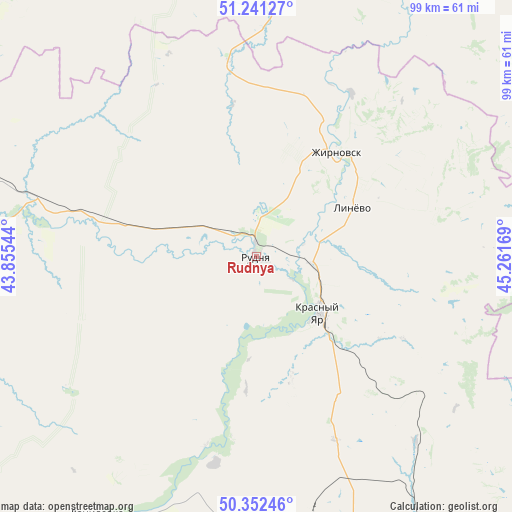
Rudnya GPS coordinates[2]
50° 47' 56.328" North, 44° 33' 30.816" East
| Map corner | latitude | longitude |
|---|---|---|
| Upper-left | 51.24127°, | 43.85544° |
| Center: | 50.79898°, | 44.55856° |
| Lower-right: | 50.35246°, | 45.26169° |
| Map W x H: | 98.8×98.8 km | = 61.4×61.4mi |
| max Lat: | 73.50819° ⇑75.6% North |
| Rudnya: | 50.79898° |
| min Lat: | ⇓24.4% South 41.28413° |
| min Long | Rudnya | max Long |
| -179.12198° | 44.55856° | 179.35046° |
| W 48.6%⇐ | ⇒51.4% E |
Elevation
Elevation of Rudnya is 112 m = 367 ft, and this is 90.6 m = 297 ft below average elevation for this country.
| Max E: |
2518 m = 8261 ft | 65.7% |
| Avg. | 202.6 m = 665 ft | |
| Rudnya | 112 m = 367 ft | |
Min E: |
-28 m = -92 ft | 34.3% |
See also: Russia elevation on elevation.city.
Geographical zone
Rudnya is located in North temperate zone (between Tropic of Cancer and the Arctic Circle). Distance of this North polar circle is 1752.9 km =1089.2 mi to North.| Distance of | km | miles | from Rudnya |
|---|---|---|---|
| North Pole | 4358.7 | 2708.4 | to North |
| Arctic Circle | 1752.9 | 1089.2 | to North |
| Tropic Cancer | 3042.4 | 1890.5 | to South |
| Equator | 5648.3 | 3509.7 | to South |


Nearby cities:
15 places around Rudnya: (largest is in red/bold)
• Danilovka
58.3 km =36.2 mi,  212°
212°
• Kalininsk
78.2 km =48.6 mi,  355°
355°
• Kamenskiy
66 km =41 mi,  81°
81°
• Kamyshin
98.8 km =61.4 mi,  142°
142°
• Kikvidze
106.1 km =65.9 mi,  266°
266°
• Kotovo
55.8 km =34.7 mi,  162°
162°
• Krasnoarmeysk
83.6 km =51.9 mi,  72°
72°
• Krasnyy Yar
16.5 km =10.3 mi,  133°
133°
• Lysyye Gory
85.9 km =53.4 mi,  13°
13°
• Medveditskiy
11 km =6.8 mi,  98°
98°
• Petrov Val
86.2 km =53.6 mi,  147°
147°
• Rovnoye
104.9 km =65.2 mi,  91°
91°
• Samoylovka
73.3 km =45.5 mi,  305°
305°
• Yelan’
60 km =37.3 mi,  286°
286°
• Zhirnovsk
25.5 km =15.8 mi,  36°
36°
Sources, notices
• [Note1] Compared only with cities in Russia existing in our database
• [Src1] Map data: © OpenStreetMap contributors (CC-BY-SA)
• [Src2] Other city data from geonames.org with taken over terms of usage.
• [Src3] Geographical zone / Annual Mean Temperature by Robert A. Rohde @ Wikipedia
