Kantemirovka geodata
Kantemirovka (Voronezj) is a seat of a second-order administrative division; located in Russia in Europe/Moscow (GMT+3) time zone. With population of 12,770 people, there are 1220 cities with bigger population in this country. Compared to other cities in Russia, 78.4% of cities are located further ↑North; 68.3% of cities are located further →East and 56.6% of cities have higher elevation than Kantemirovka. Note1


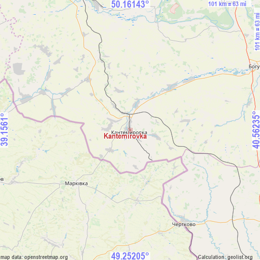
Kantemirovka GPS coordinates[2]
49° 42' 31.932" North, 39° 51' 33.192" East
| Map corner | latitude | longitude |
|---|---|---|
| Upper-left | 50.16143°, | 39.1561° |
| Center: | 49.70887°, | 39.85922° |
| Lower-right: | 49.25205°, | 40.56235° |
| Map W x H: | 101.1×101.1 km | = 62.8×62.8mi |
| max Lat: | 73.50819° ⇑78.4% North |
| Kantemirovka: | 49.70887° |
| min Lat: | ⇓21.6% South 41.28413° |
| min Long | Kantemirovka | max Long |
| -179.12198° | 39.85922° | 179.35046° |
| W 31.7%⇐ | ⇒68.3% E |
Elevation
Elevation of Kantemirovka is 131 m = 430 ft, and this is 71.6 m = 235 ft below average elevation for this country.
| Max E: |
2518 m = 8261 ft | 56.6% |
| Avg. | 202.6 m = 665 ft | |
| Kantemirovka | 131 m = 430 ft | |
Min E: |
-28 m = -92 ft | 43.4% |
See also: Russia elevation on elevation.city.
Geographical zone
Kantemirovka is located in North temperate zone (between Tropic of Cancer and the Arctic Circle). Distance of this North polar circle is 1874.1 km =1164.5 mi to North.| Distance of | km | miles | from Kantemirovka |
|---|---|---|---|
| North Pole | 4480 | 2783.7 | to North |
| Arctic Circle | 1874.1 | 1164.5 | to North |
| Tropic Cancer | 2921.2 | 1815.1 | to South |
| Equator | 5527.1 | 3434.4 | to South |


Nearby cities:
15 places around Kantemirovka: (largest is in red/bold)
• Belogor’ye
87.6 km =54.4 mi,  7°
7°
• Boguchar
55.3 km =34.4 mi,  62°
62°
• Chertkovo
41.6 km =25.8 mi,  150°
150°
• Kazanskaya
93 km =57.8 mi,  84°
84°
• Krasnovka
100.5 km =62.4 mi,  170°
170°
• Millerovo
95.7 km =59.5 mi,  155°
155°
• Mitrofanovka
31.4 km =19.5 mi,  337°
337°
• Nizhniy Mamon
71.2 km =44.2 mi,  40°
40°
• Ol’khovatka
75.8 km =47.1 mi,  327°
327°
• Pavlovsk
85.1 km =52.9 mi, 12°
• Podgorenskiy
78.9 km =49 mi,  348°
348°
• Podgornoye
80.3 km =49.9 mi, 347°
• Rossosh’
58.3 km =36.2 mi, 339°
• Verkhniy Mamon
62.9 km =39.1 mi, 36°
• Zabolotovka
74.3 km =46.2 mi, 328°
Sources, notices
• [Note1] Compared only with cities in Russia existing in our database
• [Src1] Map data: © OpenStreetMap contributors (CC-BY-SA)
• [Src2] Other city data from geonames.org with taken over terms of usage.
• [Src3] Geographical zone / Annual Mean Temperature by Robert A. Rohde @ Wikipedia
