Savinskaya geodata
Savinskaya (Moscow Oblast) is a populated place; located in Russia in Europe/Moscow (GMT+3) time zone. With population of 1,587 people, there are 4344 cities with bigger population in this country. Compared to other cities in Russia, 56.9% of cities are located further ↓South; 67.5% of cities are located further →East and 60% of cities have higher elevation than Savinskaya. Note1


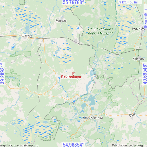
Savinskaya GPS coordinates[2]
55° 22' 12.468" North, 39° 59' 32.388" East
| Map corner | latitude | longitude |
|---|---|---|
| Upper-left | 55.76768°, | 39.28921° |
| Center: | 55.37013°, | 39.99233° |
| Lower-right: | 54.96854°, | 40.69546° |
| Map W x H: | 88.9×88.9 km | = 55.2×55.2mi |
| max Lat: | 73.50819° ⇑43.1% North |
| Savinskaya: | 55.37013° |
| min Lat: | ⇓56.9% South 41.28413° |
| min Long | Savinskaya | max Long |
| -179.12198° | 39.99233° | 179.35046° |
| W 32.5%⇐ | ⇒67.5% E |
Elevation
Elevation of Savinskaya is 124 m = 407 ft, and this is 78.6 m = 258 ft below average elevation for this country.
| Max E: |
2518 m = 8261 ft | 60% |
| Avg. | 202.6 m = 665 ft | |
| Savinskaya | 124 m = 407 ft | |
Min E: |
-28 m = -92 ft | 40% |
See also: Russia elevation on elevation.city.
Geographical zone
Savinskaya is located in North temperate zone (between Tropic of Cancer and the Arctic Circle). Distance of this North polar circle is 1244.6 km =773.4 mi to North.| Distance of | km | miles | from Savinskaya |
|---|---|---|---|
| North Pole | 3850.5 | 2392.6 | to North |
| Arctic Circle | 1244.6 | 773.4 | to North |
| Tropic Cancer | 3550.7 | 2206.3 | to South |
| Equator | 6156.6 | 3825.5 | to South |


Nearby cities:
15 places around Savinskaya: (largest is in red/bold)
• Baksheyevo
38.3 km =23.8 mi,  349°
349°
• Cherusti
20 km =12.4 mi,  3°
3°
• Dmitrovskiy Pogost
11.9 km =7.4 mi,  237°
237°
• Erleks
35.7 km =22.2 mi,  43°
43°
• Kerva
37.5 km =23.3 mi,  315°
315°
• Kurlovo
31.9 km =19.8 mi,  77°
77°
• Mezinovskiy
27.5 km =17.1 mi,  57°
57°
• Misheronskiy
42 km =26.1 mi,  337°
337°
• Radovitskiy
29.6 km =18.4 mi,  204°
204°
• Roshal’
34 km =21.1 mi, 347°
• Shatura
36.5 km =22.7 mi,  308°
308°
• Shaturtorf
42.1 km =26.2 mi,  301°
301°
• Spas-Klepiki
28.7 km =17.8 mi,  155°
155°
• Tugolesskiy Bor
22.7 km =14.1 mi,  332°
332°
• Urshel’skiy
37.1 km =23.1 mi,  22°
22°
Sources, notices
• [Note1] Compared only with cities in Russia existing in our database
• [Src1] Map data: © OpenStreetMap contributors (CC-BY-SA)
• [Src2] Other city data from geonames.org with taken over terms of usage.
• [Src3] Geographical zone / Annual Mean Temperature by Robert A. Rohde @ Wikipedia
