Mordovo geodata
Mordovo (Tambov) is a populated place; located in Russia in Europe/Moscow (GMT+3) time zone. With population of 7,112 people, there are 1970 cities with bigger population in this country. Compared to other cities in Russia, 68.7% of cities are located further ↑North; 63.9% of cities are located further →East and 57.3% of cities have higher elevation than Mordovo. Note1


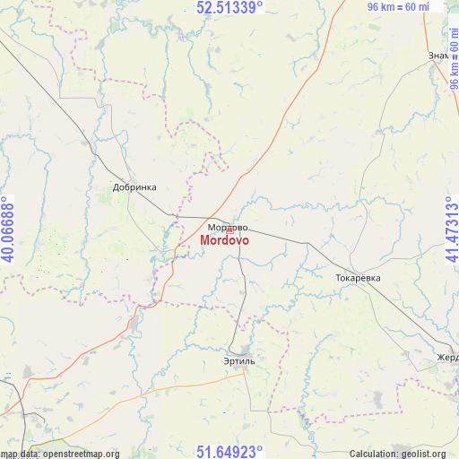
Mordovo GPS coordinates[2]
52° 5' 0.24" North, 40° 46' 12" East
| Map corner | latitude | longitude |
|---|---|---|
| Upper-left | 52.51339°, | 40.06688° |
| Center: | 52.0834°, | 40.77° |
| Lower-right: | 51.64923°, | 41.47313° |
| Map W x H: | 96.1×96.1 km | = 59.7×59.7mi |
| max Lat: | 73.50819° ⇑68.7% North |
| Mordovo: | 52.0834° |
| min Lat: | ⇓31.3% South 41.28413° |
| min Long | Mordovo | max Long |
| -179.12198° | 40.77° | 179.35046° |
| W 36.1%⇐ | ⇒63.9% E |
Elevation
Elevation of Mordovo is 130 m = 427 ft, and this is 72.6 m = 238 ft below average elevation for this country.
| Max E: |
2518 m = 8261 ft | 57.3% |
| Avg. | 202.6 m = 665 ft | |
| Mordovo | 130 m = 427 ft | |
Min E: |
-28 m = -92 ft | 42.7% |
See also: Russia elevation on elevation.city.
Geographical zone
Mordovo is located in North temperate zone (between Tropic of Cancer and the Arctic Circle). Distance of this North polar circle is 1610 km =1000.4 mi to North.| Distance of | km | miles | from Mordovo |
|---|---|---|---|
| North Pole | 4215.9 | 2619.6 | to North |
| Arctic Circle | 1610 | 1000.4 | to North |
| Tropic Cancer | 3185.2 | 1979.2 | to South |
| Equator | 5791.1 | 3598.4 | to South |


Nearby cities:
15 places around Mordovo: (largest is in red/bold)
• Anna
70.6 km =43.9 mi,  199°
199°
• Dobrinka
22.2 km =13.8 mi,  294°
294°
• Ertil’
27.1 km =16.8 mi,  174°
174°
• Novopokrovka
9.2 km =5.7 mi,  53°
53°
• Panino
65.3 km =40.6 mi,  221°
221°
• Pereleshino
57.9 km =36 mi,  228°
228°
• Pereleshinskiy
56.9 km =35.4 mi, 223°
• Petrovskiy
19.4 km =12.1 mi,  335°
335°
• Prigorodka
72.4 km =45 mi,  266°
266°
• Sadovoye
64.1 km =39.8 mi, 196°
• Satinka
70.3 km =43.7 mi,  62°
62°
• Usman’
71.3 km =44.3 mi, 266°
• Verkhnyaya Khava
62.9 km =39.1 mi,  244°
244°
• Zherdevka
54 km =33.6 mi,  118°
118°
• Znamenka
58.3 km =36.2 mi, 50°
Sources, notices
• [Note1] Compared only with cities in Russia existing in our database
• [Src1] Map data: © OpenStreetMap contributors (CC-BY-SA)
• [Src2] Other city data from geonames.org with taken over terms of usage.
• [Src3] Geographical zone / Annual Mean Temperature by Robert A. Rohde @ Wikipedia
