Mezhdurechensk geodata
Mezhdurechensk (Komi) is a populated place; located in Russia in Europe/Moscow (GMT+3) time zone. With population of 1,855 people, there are 4233 cities with bigger population in this country. Compared to other cities in Russia, 96.4% of cities are located further ↓South; 60.2% of cities are located further ←West and 56.3% of cities have lower elevation than Mezhdurechensk. Note1


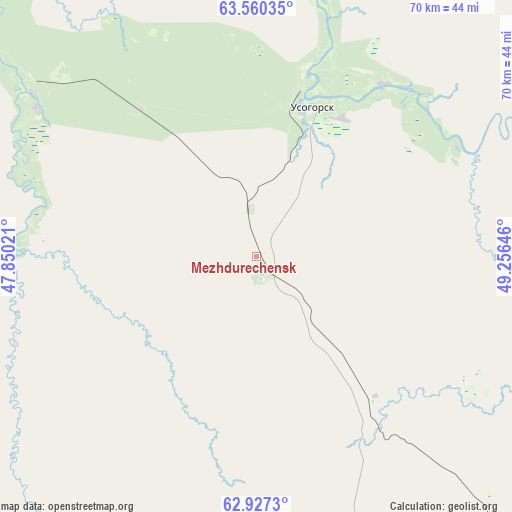
Mezhdurechensk GPS coordinates[2]
63° 14' 44.016" North, 48° 33' 11.988" East
| Map corner | latitude | longitude |
|---|---|---|
| Upper-left | 63.56035°, | 47.85021° |
| Center: | 63.24556°, | 48.55333° |
| Lower-right: | 62.9273°, | 49.25646° |
| Map W x H: | 70.4×70.4 km | = 43.7×43.7mi |
| max Lat: | 73.50819° ⇑3.6% North |
| Mezhdurechensk: | 63.24556° |
| min Lat: | ⇓96.4% South 41.28413° |
| min Long | Mezhdurechensk | max Long |
| -179.12198° | 48.55333° | 179.35046° |
| W 60.2%⇐ | ⇒39.8% E |
Elevation
Elevation of Mezhdurechensk is 159 m = 522 ft, and this is 43.6 m = 143 ft below average elevation for this country.
| Max E: |
2518 m = 8261 ft | 43.7% |
| Avg. | 202.6 m = 665 ft | |
| Mezhdurechensk | 159 m = 522 ft | |
Min E: |
-28 m = -92 ft | 56.3% |
See also: Russia elevation on elevation.city.
Geographical zone
Mezhdurechensk is located in North temperate zone (between Tropic of Cancer and the Arctic Circle). Distance of this North polar circle is 368.9 km =229.2 mi to North.| Distance of | km | miles | from Mezhdurechensk |
|---|---|---|---|
| North Pole | 2974.8 | 1848.5 | to North |
| Arctic Circle | 368.9 | 229.2 | to North |
| Tropic Cancer | 4426.3 | 2750.4 | to South |
| Equator | 7032.2 | 4369.6 | to South |


Nearby cities:
15 places around Mezhdurechensk: (largest is in red/bold)
• Aykino
135.1 km =83.9 mi,  147°
147°
• Blagoyevo
35.4 km =22 mi,  303°
303°
• Ezhva
194.5 km =120.9 mi, 145°
• Koslan
29.1 km =18.1 mi,  36°
36°
• Mikun’
125.7 km =78.1 mi,  141°
141°
• Sedkyrkeshch
205.8 km =127.9 mi, 143°
• Sindor
173.4 km =107.7 mi,  104°
104°
• Syktyvkar
210.8 km =131 mi, 146°
• Urdoma
165.9 km =103.1 mi,  180°
180°
• Usogorsk
19.5 km =12.1 mi,  20°
20°
• Ust’-Vym’
147 km =91.3 mi, 140°
• Yarensk
123 km =76.4 mi,  167°
167°
• Yemva
137.6 km =85.5 mi,  121°
121°
• Zelenets
188.5 km =117.1 mi, 143°
• Zheshart
140.4 km =87.2 mi,  158°
158°
Sources, notices
• [Note1] Compared only with cities in Russia existing in our database
• [Src1] Map data: © OpenStreetMap contributors (CC-BY-SA)
• [Src2] Other city data from geonames.org with taken over terms of usage.
• [Src3] Geographical zone / Annual Mean Temperature by Robert A. Rohde @ Wikipedia
