Karakulino geodata
Karakulino (Udmurtiya Republic) is a populated place; located in Russia in Europe/Samara (GMT+4) time zone. With population of 5,052 people, there are 2638 cities with bigger population in this country. Compared to other cities in Russia, 66.7% of cities are located further ↓South; 65.3% of cities are located further ←West and 65.7% of cities have higher elevation than Karakulino. Note1


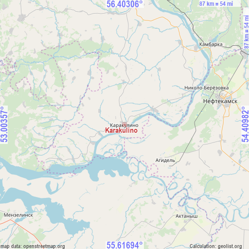
Karakulino GPS coordinates[2]
56° 0' 43.2" North, 53° 42' 24.084" East
| Map corner | latitude | longitude |
|---|---|---|
| Upper-left | 56.40306°, | 53.00357° |
| Center: | 56.012°, | 53.70669° |
| Lower-right: | 55.61694°, | 54.40982° |
| Map W x H: | 87.4×87.4 km | = 54.3×54.3mi |
| max Lat: | 73.50819° ⇑33.3% North |
| Karakulino: | 56.012° |
| min Lat: | ⇓66.7% South 41.28413° |
| min Long | Karakulino | max Long |
| -179.12198° | 53.70669° | 179.35046° |
| W 65.3%⇐ | ⇒34.7% E |
Elevation
Elevation of Karakulino is 112 m = 367 ft, and this is 90.6 m = 297 ft below average elevation for this country.
| Max E: |
2518 m = 8261 ft | 65.7% |
| Avg. | 202.6 m = 665 ft | |
| Karakulino | 112 m = 367 ft | |
Min E: |
-28 m = -92 ft | 34.3% |
See also: Russia elevation on elevation.city.
Geographical zone
Karakulino is located in North temperate zone (between Tropic of Cancer and the Arctic Circle). Distance of this North polar circle is 1173.2 km =729 mi to North.| Distance of | km | miles | from Karakulino |
|---|---|---|---|
| North Pole | 3779.1 | 2348.2 | to North |
| Arctic Circle | 1173.2 | 729 | to North |
| Tropic Cancer | 3622 | 2250.6 | to South |
| Equator | 6228 | 3869.9 | to South |


Nearby cities:
15 places around Karakulino: (largest is in red/bold)
• Agidel’
18.4 km =11.4 mi,  129°
129°
• Agryz
71.6 km =44.5 mi,  322°
322°
• Aktanysh
39.9 km =24.8 mi,  143°
143°
• Amzya
48.8 km =30.3 mi,  59°
59°
• Kaltasy
68.4 km =42.5 mi,  93°
93°
• Kama
40.5 km =25.2 mi,  36°
36°
• Kambarka
41.9 km =26 mi,  47°
47°
• Kiyasovo
52 km =32.3 mi, 316°
• Malaya Purga
74.5 km =46.3 mi, 324°
• Menzelinsk
49.2 km =30.6 mi,  229°
229°
• Neftekamsk
35.9 km =22.3 mi,  75°
75°
• Nikolo-Berëzovka
30.5 km =19 mi,  65°
65°
• Sarapul
51.9 km =32.2 mi,  6°
6°
• Sigayevo
45.7 km =28.4 mi, 5°
• Verkhneyarkeyevo
73.1 km =45.4 mi,  148°
148°
Sources, notices
• [Note1] Compared only with cities in Russia existing in our database
• [Src1] Map data: © OpenStreetMap contributors (CC-BY-SA)
• [Src2] Other city data from geonames.org with taken over terms of usage.
• [Src3] Geographical zone / Annual Mean Temperature by Robert A. Rohde @ Wikipedia
