Aktanysh geodata
Aktanysh (Tatarstan Republic) is a populated place; located in Russia in Europe/Moscow (GMT+3) time zone. With population of 8,163 people, there are 1774 cities with bigger population in this country. Compared to other cities in Russia, 62.1% of cities are located further ↓South; 65.7% of cities are located further ←West and 81.1% of cities have higher elevation than Aktanysh. Note1


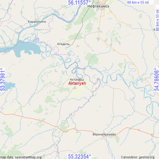
Aktanysh GPS coordinates[2]
55° 43' 17.616" North, 54° 4' 58.548" East
| Map corner | latitude | longitude |
|---|---|---|
| Upper-left | 56.11557°, | 53.37981° |
| Center: | 55.72156°, | 54.08293° |
| Lower-right: | 55.32354°, | 54.78606° |
| Map W x H: | 88.1×88.1 km | = 54.7×54.7mi |
| max Lat: | 73.50819° ⇑37.9% North |
| Aktanysh: | 55.72156° |
| min Lat: | ⇓62.1% South 41.28413° |
| min Long | Aktanysh | max Long |
| -179.12198° | 54.08293° | 179.35046° |
| W 65.7%⇐ | ⇒34.3% E |
Elevation
Elevation of Aktanysh is 67 m = 220 ft, and this is 135.6 m = 445 ft below average elevation for this country.
| Max E: |
2518 m = 8261 ft | 81.1% |
| Avg. | 202.6 m = 665 ft | |
| Aktanysh | 67 m = 220 ft | |
Min E: |
-28 m = -92 ft | 18.9% |
See also: Russia elevation on elevation.city.
Geographical zone
Aktanysh is located in North temperate zone (between Tropic of Cancer and the Arctic Circle). Distance of this North polar circle is 1205.5 km =749.1 mi to North.| Distance of | km | miles | from Aktanysh |
|---|---|---|---|
| North Pole | 3811.4 | 2368.3 | to North |
| Arctic Circle | 1205.5 | 749.1 | to North |
| Tropic Cancer | 3589.7 | 2230.5 | to South |
| Equator | 6195.7 | 3849.8 | to South |


Nearby cities:
15 places around Aktanysh: (largest is in red/bold)
• Agidel’
22.7 km =14.1 mi,  336°
336°
• Amzya
60.1 km =37.3 mi,  18°
18°
• Bakaly
62.9 km =39.1 mi,  196°
196°
• Dyurtyuli
55.6 km =34.5 mi,  117°
117°
• Kaltasy
52.7 km =32.7 mi,  58°
58°
• Kama
64.9 km =40.3 mi,  0°
0°
• Kambarka
61.1 km =38 mi,  7°
7°
• Karakulino
39.9 km =24.8 mi,  323°
323°
• Krasnokholmskiy
67 km =41.6 mi, 63°
• Menzelinsk
61.4 km =38.2 mi,  270°
270°
• Muslyumovo
72.7 km =45.2 mi,  230°
230°
• Neftekamsk
42.7 km =26.5 mi, 15°
• Nikolo-Berëzovka
45 km =28 mi, 5°
• Semiletka
52.3 km =32.5 mi,  140°
140°
• Verkhneyarkeyevo
33.5 km =20.8 mi,  154°
154°
Sources, notices
• [Note1] Compared only with cities in Russia existing in our database
• [Src1] Map data: © OpenStreetMap contributors (CC-BY-SA)
• [Src2] Other city data from geonames.org with taken over terms of usage.
• [Src3] Geographical zone / Annual Mean Temperature by Robert A. Rohde @ Wikipedia
