Bugul’ma geodata
Bugul’ma (Tatarstan Republic) is a populated place; located in Russia in Europe/Moscow (GMT+3) time zone. With population of 91,900 people, there are 233 cities with bigger population in this country. Compared to other cities in Russia, 50.8% of cities are located further ↑North; 64.7% of cities are located further ←West and 83.4% of cities have lower elevation than Bugul’ma. Note1


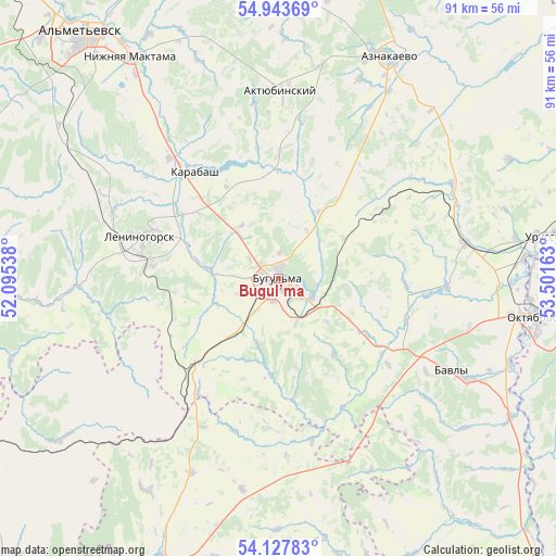
Bugul’ma GPS coordinates[2]
54° 32' 16.08" North, 52° 47' 54.6" East
| Map corner | latitude | longitude |
|---|---|---|
| Upper-left | 54.94369°, | 52.09538° |
| Center: | 54.5378°, | 52.7985° |
| Lower-right: | 54.12783°, | 53.50163° |
| Map W x H: | 90.7×90.7 km | = 56.4×56.4mi |
| max Lat: | 73.50819° ⇑50.8% North |
| Bugul’ma: | 54.5378° |
| min Lat: | ⇓49.2% South 41.28413° |
| min Long | Bugul’ma | max Long |
| -179.12198° | 52.7985° | 179.35046° |
| W 64.7%⇐ | ⇒35.3% E |
Elevation
Elevation of Bugul’ma is 292 m = 958 ft, and this is 89.4 m = 293 ft above average elevation for this country.
| Max E: |
2518 m = 8261 ft | 16.6% |
| Bugul’ma | 292 m 958 ft | |
| Avg. | 202.6 m = 665 ft | |
Min E: |
-28 m = -92 ft | 83.4% |
See also: Bugul’ma elevation on elevation.city.
Geographical zone
Bugul’ma is located in North temperate zone (between Tropic of Cancer and the Arctic Circle). Distance of this North polar circle is 1337.1 km =830.8 mi to North.| Distance of | km | miles | from Bugul’ma |
|---|---|---|---|
| North Pole | 3943 | 2450.1 | to North |
| Arctic Circle | 1337.1 | 830.8 | to North |
| Tropic Cancer | 3458.1 | 2148.8 | to South |
| Equator | 6064 | 3768 | to South |


Nearby cities:
15 places around Bugul’ma: (largest is in red/bold)
• Aktyubinskiy
30.7 km =19.1 mi,  0°
0°
• Al’met’yevsk
51.2 km =31.8 mi,  322°
322°
• Bavly
33.9 km =21.1 mi,  118°
118°
• Dzhalil’
54.2 km =33.7 mi,  355°
355°
• Kamyshla
63.2 km =39.3 mi,  222°
222°
• Karabash
22.1 km =13.7 mi, 321°
• Klyavlino
58.4 km =36.3 mi,  238°
238°
• Leninogorsk
22.9 km =14.2 mi,  288°
288°
• Nizhnetroitskiy
61.4 km =38.2 mi,  111°
111°
• Nizhnyaya Maktama
43.3 km =26.9 mi,  326°
326°
• Oktyabr’skiy
43.9 km =27.3 mi,  98°
98°
• Severnoye
52.1 km =32.4 mi,  198°
198°
• Shugurovo
43.1 km =26.8 mi,  265°
265°
• Tuymazy
59.2 km =36.8 mi,  82°
82°
• Urussu
43.4 km =27 mi, 81°
Sources, notices
• [Note1] Compared only with cities in Russia existing in our database
• [Src1] Map data: © OpenStreetMap contributors (CC-BY-SA)
• [Src2] Other city data from geonames.org with taken over terms of usage.
• [Src3] Geographical zone / Annual Mean Temperature by Robert A. Rohde @ Wikipedia
