Urussu geodata
Urussu (Tatarstan Republic) is a populated place; located in Russia in Europe/Moscow (GMT+3) time zone. With population of 11,279 people, there are 1341 cities with bigger population in this country. Compared to other cities in Russia, 50.4% of cities are located further ↑North; 65.1% of cities are located further ←West and 68.2% of cities have higher elevation than Urussu. Note1


Urussu GPS coordinates[2]
54° 35' 53.232" North, 53° 27' 47.268" East
| Map corner | latitude | longitude |
|---|---|---|
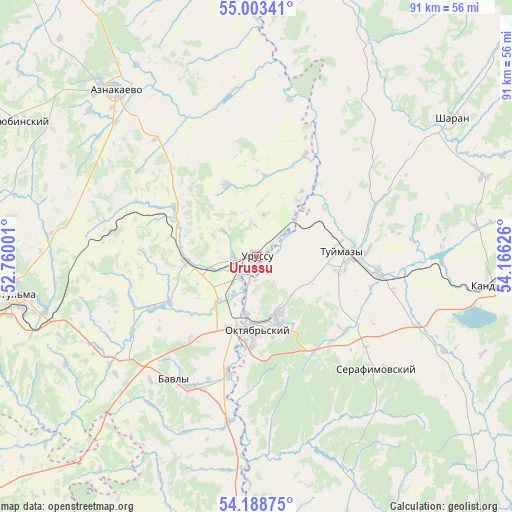
| Upper-left | 55.00341°, | 52.76001° |
| Center: | 54.59812°, | 53.46313° |
| Lower-right: | 54.18875°, | 54.16626° |
| Map W x H: | 90.6×90.6 km | = 56.3×56.3mi |
| max Lat: | 73.50819° ⇑50.4% North |
| Urussu: | 54.59812° |
| min Lat: | ⇓49.6% South 41.28413° |
| min Long | Urussu | max Long |
| -179.12198° | 53.46313° | 179.35046° |
| W 65.1%⇐ | ⇒34.9% E |
Elevation
Elevation of Urussu is 107 m = 351 ft, and this is 95.6 m = 314 ft below average elevation for this country.
| Max E: |
2518 m = 8261 ft | 68.2% |
| Avg. | 202.6 m = 665 ft | |
| Urussu | 107 m = 351 ft | |
Min E: |
-28 m = -92 ft | 31.8% |
See also: Russia elevation on elevation.city.
Geographical zone
Urussu is located in North temperate zone (between Tropic of Cancer and the Arctic Circle). Distance of this North polar circle is 1330.4 km =826.7 mi to North.| Distance of | km | miles | from Urussu |
|---|---|---|---|
| North Pole | 3936.3 | 2445.9 | to North |
| Arctic Circle | 1330.4 | 826.7 | to North |
| Tropic Cancer | 3464.8 | 2152.9 | to South |
| Equator | 6070.7 | 3772.2 | to South |


Nearby cities:
15 places around Urussu: (largest is in red/bold)
• Aktyubinskiy
48.6 km =30.2 mi,  299°
299°
• Bakaly
68.1 km =42.3 mi,  18°
18°
• Bavly
26.3 km =16.3 mi,  209°
209°
• Bugul’ma
43.4 km =27 mi,  261°
261°
• Dzhalil’
66.4 km =41.3 mi,  315°
315°
• Kandry
42.3 km =26.3 mi,  94°
94°
• Karabash
57.6 km =35.8 mi,  280°
280°
• Leninogorsk
64.6 km =40.1 mi,  270°
270°
• Nizhnetroitskiy
32.2 km =20 mi,  153°
153°
• Oktyabr’skiy
13 km =8.1 mi,  177°
177°
• Serafimovskiy
28.9 km =18 mi,  131°
131°
• Sharan
42.2 km =26.2 mi,  54°
54°
• Subkhankulovo
22.9 km =14.2 mi,  101°
101°
• Tuymazy
15.9 km =9.9 mi, 86°
• Yermekeyevo
59.6 km =37 mi,  166°
166°
Sources, notices
• [Note1] Compared only with cities in Russia existing in our database
• [Src1] Map data: © OpenStreetMap contributors (CC-BY-SA)
• [Src2] Other city data from geonames.org with taken over terms of usage.
• [Src3] Geographical zone / Annual Mean Temperature by Robert A. Rohde @ Wikipedia
