Zyryanskoye geodata
Zyryanskoye (Tomsk Oblast) is a populated place; located in Russia in Asia/Tomsk (GMT+7) time zone. With population of 6,285 people, there are 2186 cities with bigger population in this country. Compared to other cities in Russia, 75.6% of cities are located further ↓South; 84.4% of cities are located further ←West and 66.6% of cities have higher elevation than Zyryanskoye. Note1


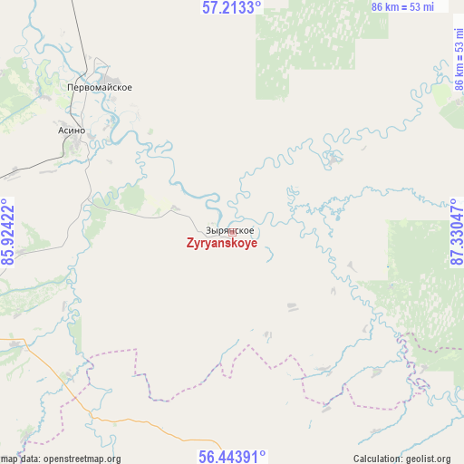
Zyryanskoye GPS coordinates[2]
56° 49' 50.088" North, 86° 37' 38.424" East
| Map corner | latitude | longitude |
|---|---|---|
| Upper-left | 57.2133°, | 85.92422° |
| Center: | 56.83058°, | 86.62734° |
| Lower-right: | 56.44391°, | 87.33047° |
| Map W x H: | 85.5×85.5 km | = 53.1×53.1mi |
| max Lat: | 73.50819° ⇑24.4% North |
| Zyryanskoye: | 56.83058° |
| min Lat: | ⇓75.6% South 41.28413° |
| min Long | Zyryanskoye | max Long |
| -179.12198° | 86.62734° | 179.35046° |
| W 84.4%⇐ | ⇒15.6% E |
Elevation
Elevation of Zyryanskoye is 110 m = 361 ft, and this is 92.6 m = 304 ft below average elevation for this country.
| Max E: |
2518 m = 8261 ft | 66.6% |
| Avg. | 202.6 m = 665 ft | |
| Zyryanskoye | 110 m = 361 ft | |
Min E: |
-28 m = -92 ft | 33.4% |
See also: Russia elevation on elevation.city.
Geographical zone
Zyryanskoye is located in North temperate zone (between Tropic of Cancer and the Arctic Circle). Distance of this North polar circle is 1082.2 km =672.4 mi to North.| Distance of | km | miles | from Zyryanskoye |
|---|---|---|---|
| North Pole | 3688.1 | 2291.7 | to North |
| Arctic Circle | 1082.2 | 672.4 | to North |
| Tropic Cancer | 3713 | 2307.2 | to South |
| Equator | 6319 | 3926.4 | to South |


Nearby cities:
15 places around Zyryanskoye: (largest is in red/bold)
• Aleksandrovskoye
76 km =47.2 mi,  262°
262°
• Anzhero-Sudzhensk
91.1 km =56.6 mi,  203°
203°
• Asino
34.9 km =21.7 mi,  302°
302°
• Bogashevo
104.3 km =64.8 mi,  240°
240°
• Izhmorskiy
71 km =44.1 mi,  179°
179°
• Mariinsk
97.1 km =60.3 mi,  134°
134°
• Pervomayskoye
36.4 km =22.6 mi,  318°
318°
• Rudnichnyy
86.1 km =53.5 mi, 195°
• Seversk
109.3 km =67.9 mi, 256°
• Svetlyy
41.3 km =25.7 mi,  283°
283°
• Tayga
105.3 km =65.4 mi,  215°
215°
• Tegul’det
106.7 km =66.3 mi,  60°
60°
• Tomsk
107.6 km =66.9 mi,  249°
249°
• Verkh-Chebula
107.9 km =67 mi,  145°
145°
• Yaya
70.4 km =43.7 mi,  189°
189°
Sources, notices
• [Note1] Compared only with cities in Russia existing in our database
• [Src1] Map data: © OpenStreetMap contributors (CC-BY-SA)
• [Src2] Other city data from geonames.org with taken over terms of usage.
• [Src3] Geographical zone / Annual Mean Temperature by Robert A. Rohde @ Wikipedia
