Port Sudan geodata
Port Sudan (Red Sea) is a seat of a first-order administrative division; located in Sudan in Africa/Khartoum (GMT+2) time zone. With population of 489,725 people, there are 3 cities with bigger population in this country. Compared to other cities in Sudan, 97.2% of cities are located further ↓South; 97.2% of cities are located further ←West and 98.6% of cities have higher elevation than Port Sudan. Note1


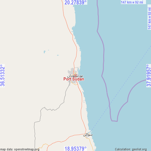
Port Sudan GPS coordinates[2]
19° 37' 2.82" North, 37° 12' 59.184" East
| Map corner | latitude | longitude |
|---|---|---|
| Upper-left | 20.27839°, | 36.51332° |
| Center: | 19.61745°, | 37.21644° |
| Lower-right: | 18.95379°, | 37.91957° |
| Map W x H: | 147.3×147.3 km | = 91.5×91.5mi |
| max Lat: | 21.06667° ⇑2.8% North |
| Port Sudan: | 19.61745° |
| min Lat: | ⇓97.2% South 10.55° |
| min Long | Port Sudan | max Long |
| 22.44725° | 37.21644° | 37.729° |
| W 97.2%⇐ | ⇒2.8% E |
Elevation
Elevation of Port Sudan is 10 m = 33 ft, and this is 439.1 m = 1441 ft below average elevation for this country.
| Max E: |
1159 m = 3802 ft | 98.6% |
| Avg. | 449.1 m = 1473 ft | |
| Port Sudan | 10 m = 33 ft | |
Min E: |
4 m = 13 ft | 1.4% |
See also: Port Sudan elevation on elevation.city.
Geographical zone
Port Sudan is located in North Torrid zone (between Equator and Tropic of Cancer). Distance of this Northern Tropic circle is 424.7 km =263.9 mi to North.| Distance of | km | miles | from Port Sudan |
|---|---|---|---|
| North Pole | 7825.8 | 4862.7 | to North |
| Arctic Circle | 5219.9 | 3243.5 | to North |
| Tropic Cancer | 424.7 | 263.9 | to North |
| Equator | 2181.3 | 1355.4 | to South |


Nearby cities:
9 places around Port Sudan: (largest is in red/bold)
• Aroma
437.9 km =272.1 mi,  195°
195°
• Atbara
401.4 km =249.4 mi,  237°
237°
• Berber
383.8 km =238.5 mi, 242°
• Ed Damer
408.9 km =254.1 mi, 236°
• El Bauga
379.2 km =235.6 mi,  246°
246°
• Gebeit
186.5 km =115.9 mi,  329°
329°
• Sawākin
58.2 km =36.2 mi,  167°
167°
• Tokār
143.1 km =88.9 mi,  157°
157°
• Wagar
399.9 km =248.5 mi, 195°
In other languages:
- In Spanish: Puerto Sudán
- In France: Port-Soudan
- In German: Bur Sudan
- In Italian: Porto Sudan
- In Russian: Порт-Судан
- In Chinese: 苏丹港
Sources, notices
• [Note1] Compared only with cities in Sudan existing in our database
• [Src1] Map data: © OpenStreetMap contributors (CC-BY-SA)
• [Src2] Other city data from geonames.org with taken over terms of usage.
• [Src3] Geographical zone / Annual Mean Temperature by Robert A. Rohde @ Wikipedia
