Ed Damer geodata
Ed Damer (River Nile) is a seat of a first-order administrative division; located in Sudan in Africa/Khartoum (GMT+2) time zone. With population of 103,941 people, there are 20 cities with bigger population in this country. Compared to other cities in Sudan, 81.7% of cities are located further ↓South; 76.1% of cities are located further ←West and 84.5% of cities have higher elevation than Ed Damer. Note1


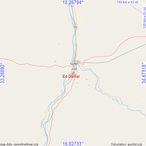
Ed Damer GPS coordinates[2]
17° 35' 56.328" North, 33° 58' 19.38" East
| Map corner | latitude | longitude |
|---|---|---|
| Upper-left | 18.26794°, | 33.26893° |
| Center: | 17.59898°, | 33.97205° |
| Lower-right: | 16.92753°, | 34.67518° |
| Map W x H: | 149×149 km | = 92.6×92.6mi |
| max Lat: | 21.06667° ⇑18.3% North |
| Ed Damer: | 17.59898° |
| min Lat: | ⇓81.7% South 10.55° |
| min Long | Ed Damer | max Long |
| 22.44725° | 33.97205° | 37.729° |
| W 76.1%⇐ | ⇒23.9% E |
Elevation
Elevation of Ed Damer is 354 m = 1161 ft, and this is 95.1 m = 312 ft below average elevation for this country.
| Max E: |
1159 m = 3802 ft | 84.5% |
| Avg. | 449.1 m = 1473 ft | |
| Ed Damer | 354 m = 1161 ft | |
Min E: |
4 m = 13 ft | 15.5% |
See also: Ed Damer elevation on elevation.city.
Geographical zone
Ed Damer is located in North Torrid zone (between Equator and Tropic of Cancer). Distance of this Northern Tropic circle is 649.1 km =403.3 mi to North.| Distance of | km | miles | from Ed Damer |
|---|---|---|---|
| North Pole | 8050.2 | 5002.2 | to North |
| Arctic Circle | 5444.4 | 3383 | to North |
| Tropic Cancer | 649.1 | 403.3 | to North |
| Equator | 1956.8 | 1215.9 | to South |


Nearby cities:
15 places around Ed Damer: (largest is in red/bold)
• Ad Dabbah
323.8 km =201.2 mi,  278°
278°
• Al Hasaheisa
324.6 km =201.7 mi,  192°
192°
• Al Hilāliyya
306 km =190.1 mi, 194°
• Aroma
303.7 km =188.7 mi,  130°
130°
• Atbara
11.6 km =7.2 mi,  7°
7°
• Berber
47 km =29.2 mi,  1°
1°
• El Bauga
74 km =46 mi,  354°
354°
• El Matama
118.6 km =73.7 mi,  213°
213°
• Khartoum
274.5 km =170.6 mi, 213°
• Kuraymah
248 km =154.1 mi,  295°
295°
• Merowe
248.1 km =154.2 mi,  292°
292°
• Omdurman
269.4 km =167.4 mi,  216°
216°
• Shendi
116 km =72.1 mi, 209°
• Wad Rāwah
285.3 km =177.3 mi,  198°
198°
• Wagar
286.7 km =178.1 mi,  124°
124°
Sources, notices
• [Note1] Compared only with cities in Sudan existing in our database
• [Src1] Map data: © OpenStreetMap contributors (CC-BY-SA)
• [Src2] Other city data from geonames.org with taken over terms of usage.
• [Src3] Geographical zone / Annual Mean Temperature by Robert A. Rohde @ Wikipedia
