Sawākin geodata
Sawākin (Red Sea) is a populated place; located in Sudan in Africa/Khartoum (GMT+2) time zone. With population of 28,570 people, there are 31 cities with bigger population in this country. Compared to other cities in Sudan, 93% of cities are located further ↓South; 98.6% of cities are located further ←West and 100% of cities have higher elevation than Sawākin. Note1


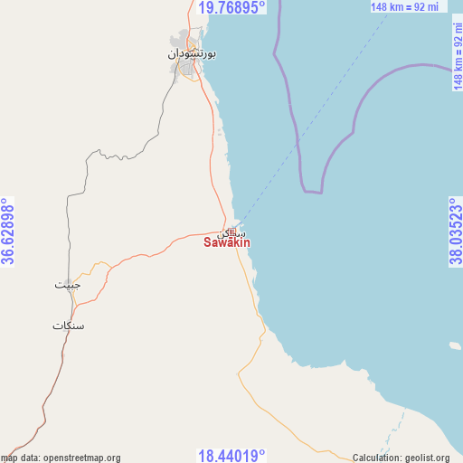
Sawākin GPS coordinates[2]
19° 6' 21.24" North, 37° 19' 55.56" East
| Map corner | latitude | longitude |
|---|---|---|
| Upper-left | 19.76895°, | 36.62898° |
| Center: | 19.1059°, | 37.3321° |
| Lower-right: | 18.44019°, | 38.03523° |
| Map W x H: | 147.7×147.7 km | = 91.8×91.8mi |
| max Lat: | 21.06667° ⇑7% North |
| Sawākin: | 19.1059° |
| min Lat: | ⇓93% South 10.55° |
| min Long | Sawākin | max Long |
| 22.44725° | 37.3321° | 37.729° |
| W 98.6%⇐ | ⇒1.4% E |
Elevation
Elevation of Sawākin is 4 m = 13 ft, and this is 445.1 m = 1460 ft below average elevation for this country.
| Max E: |
1159 m = 3802 ft | 100% |
| Avg. | 449.1 m = 1473 ft | |
| Sawākin | 4 m = 13 ft | |
Min E: |
4 m = 13 ft | 0% |
See also: Sudan elevation on elevation.city.
Geographical zone
Sawākin is located in North Torrid zone (between Equator and Tropic of Cancer). Distance of this Northern Tropic circle is 481.5 km =299.2 mi to North.| Distance of | km | miles | from Sawākin |
|---|---|---|---|
| North Pole | 7882.7 | 4898.1 | to North |
| Arctic Circle | 5276.8 | 3278.9 | to North |
| Tropic Cancer | 481.5 | 299.2 | to North |
| Equator | 2124.4 | 1320 | to South |


Nearby cities:
10 places around Sawākin: (largest is in red/bold)
• Aroma
387.2 km =240.6 mi,  199°
199°
• Atbara
385.9 km =239.8 mi,  246°
246°
• Berber
373 km =231.8 mi, 251°
• Ed Damer
392.2 km =243.7 mi,  244°
244°
• El Bauga
372.6 km =231.5 mi,  255°
255°
• Gebeit
242.4 km =150.6 mi,  334°
334°
• Kassala
418.3 km =259.9 mi,  193°
193°
• Port Sudan
58.2 km =36.2 mi,  347°
347°
• Tokār
86.4 km =53.7 mi,  151°
151°
• Wagar
349.5 km =217.2 mi, 200°
Sources, notices
• [Note1] Compared only with cities in Sudan existing in our database
• [Src1] Map data: © OpenStreetMap contributors (CC-BY-SA)
• [Src2] Other city data from geonames.org with taken over terms of usage.
• [Src3] Geographical zone / Annual Mean Temperature by Robert A. Rohde @ Wikipedia
