Atbara geodata
Atbara (River Nile) is a populated place; located in Sudan in Africa/Khartoum (GMT+2) time zone. With population of 107,930 people, there are 19 cities with bigger population in this country. Compared to other cities in Sudan, 83.1% of cities are located further ↓South; 78.9% of cities are located further ←West and 83.1% of cities have higher elevation than Atbara. Note1


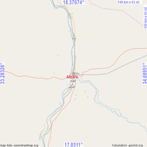
Atbara GPS coordinates[2]
17° 42' 7.812" North, 33° 59' 10.968" East
| Map corner | latitude | longitude |
|---|---|---|
| Upper-left | 18.37074°, | 33.28326° |
| Center: | 17.70217°, | 33.98638° |
| Lower-right: | 17.0311°, | 34.68951° |
| Map W x H: | 149×149 km | = 92.6×92.6mi |
| max Lat: | 21.06667° ⇑16.9% North |
| Atbara: | 17.70217° |
| min Lat: | ⇓83.1% South 10.55° |
| min Long | Atbara | max Long |
| 22.44725° | 33.98638° | 37.729° |
| W 78.9%⇐ | ⇒21.1% E |
Elevation
Elevation of Atbara is 358 m = 1175 ft, and this is 91.1 m = 299 ft below average elevation for this country.
| Max E: |
1159 m = 3802 ft | 83.1% |
| Avg. | 449.1 m = 1473 ft | |
| Atbara | 358 m = 1175 ft | |
Min E: |
4 m = 13 ft | 16.9% |
See also: Atbara elevation on elevation.city.
Geographical zone
Atbara is located in North Torrid zone (between Equator and Tropic of Cancer). Distance of this Northern Tropic circle is 637.6 km =396.2 mi to North.| Distance of | km | miles | from Atbara |
|---|---|---|---|
| North Pole | 8038.8 | 4995.1 | to North |
| Arctic Circle | 5432.9 | 3375.8 | to North |
| Tropic Cancer | 637.6 | 396.2 | to North |
| Equator | 1968.3 | 1223 | to South |


Nearby cities:
15 places around Atbara: (largest is in red/bold)
• Ad Dabbah
323.6 km =201.1 mi,  276°
276°
• Al Hasaheisa
336.1 km =208.8 mi,  192°
192°
• Al Hilāliyya
317.5 km =197.3 mi, 194°
• Aroma
310.2 km =192.7 mi,  132°
132°
• Berber
35.5 km =22.1 mi,  359°
359°
• Ed Damer
11.6 km =7.2 mi, 187°
• El Bauga
62.8 km =39 mi,  352°
352°
• El Matama
129.1 km =80.2 mi,  211°
211°
• Khartoum
284.9 km =177 mi, 212°
• Kuraymah
244.6 km =152 mi,  292°
292°
• Merowe
245.3 km =152.4 mi, 290°
• Omdurman
279.6 km =173.7 mi,  215°
215°
• Shendi
126.8 km =78.8 mi, 207°
• Wad Rāwah
296.7 km =184.4 mi,  197°
197°
• Wagar
292 km =181.4 mi, 126°
Sources, notices
• [Note1] Compared only with cities in Sudan existing in our database
• [Src1] Map data: © OpenStreetMap contributors (CC-BY-SA)
• [Src2] Other city data from geonames.org with taken over terms of usage.
• [Src3] Geographical zone / Annual Mean Temperature by Robert A. Rohde @ Wikipedia
