Valla geodata
Valla (Södermanland) is a populated place; located in Sweden in Europe/Stockholm (GMT+2) time zone. With population of 1,485 people, there are 661 cities with bigger population in this country. Compared to other cities in Sweden, 53.5% of cities are located further ↓South; 66.6% of cities are located further ←West and 65.3% of cities have higher elevation than Valla. Note1
Administrative division(s):
- Level 1: Södermanland
- Level 2: Katrineholms Kommun
- Level 3: Sköldinge
- Level 4: Sköldinge socken


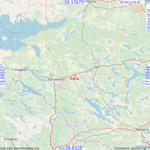
Valla GPS coordinates[2]
59° 1' 0.012" North, 16° 22' 59.988" East
| Map corner | latitude | longitude |
|---|---|---|
| Upper-left | 59.37673°, | 15.68021° |
| Center: | 59.01667°, | 16.38333° |
| Lower-right: | 58.6528°, | 17.08646° |
| Map W x H: | 80.5×80.5 km | = 50×50mi |
| max Lat: | 67.85572° ⇑46.5% North |
| Valla: | 59.01667° |
| min Lat: | ⇓53.5% South 55.34337° |
| min Long | Valla | max Long |
| 11.1712° | 16.38333° | 24.13676° |
| W 66.6%⇐ | ⇒33.4% E |
Elevation
Elevation of Valla is 30 m = 98 ft, and this is 52.6 m = 173 ft below average elevation for this country.
| Max E: |
663 m = 2175 ft | 65.3% |
| Avg. | 82.6 m = 271 ft | |
| Valla | 30 m = 98 ft | |
Min E: |
-1 m = -3 ft | 34.7% |
See also: Sweden elevation on elevation.city.
Geographical zone
Valla is located in North temperate zone (between Tropic of Cancer and the Arctic Circle). Distance of this North polar circle is 839.1 km =521.4 mi to North.| Distance of | km | miles | from Valla |
|---|---|---|---|
| North Pole | 3445 | 2140.6 | to North |
| Arctic Circle | 839.1 | 521.4 | to North |
| Tropic Cancer | 3956.1 | 2458.2 | to South |
| Equator | 6562 | 4077.4 | to South |


Nearby cities:
15 places around Valla: (largest is in red/bold)
• Bie
12.8 km =8 mi,  308°
308°
• Flen
12.6 km =7.8 mi,  68°
68°
• Forssjö
8.6 km =5.3 mi,  215°
215°
• Hälleforsnäs
16.4 km =10.2 mi,  23°
23°
• Hållsta
31.2 km =19.4 mi,  7°
7°
• Katrineholm
10.3 km =6.4 mi,  257°
257°
• Malmköping
23.8 km =14.8 mi,  57°
57°
• Mellösa
13.3 km =8.3 mi,  45°
45°
• Olstorp
26.5 km =16.5 mi,  147°
147°
• Rejmyre
33.7 km =20.9 mi,  232°
232°
• Sköldinge
4 km =2.5 mi, 66°
• Sparreholm
25.4 km =15.8 mi,  77°
77°
• Stigtomta
33.3 km =20.7 mi,  136°
136°
• Vingåker
29.3 km =18.2 mi,  275°
275°
• Vrena
25.1 km =15.6 mi,  133°
133°
Sources, notices
• [Note1] Compared only with cities in Sweden existing in our database
• [Src1] Map data: © OpenStreetMap contributors (CC-BY-SA)
• [Src2] Other city data from geonames.org with taken over terms of usage.
• [Src3] Geographical zone / Annual Mean Temperature by Robert A. Rohde @ Wikipedia
