Katrineholm geodata
Katrineholm (Södermanland) is a seat of a second-order administrative division; located in Sweden in Europe/Stockholm (GMT+2) time zone. With population of 23,283 people, there are 67 cities with bigger population in this country. Compared to other cities in Sweden, 53.3% of cities are located further ↓South; 64.2% of cities are located further ←West and 50.7% of cities have lower elevation than Katrineholm. Note1


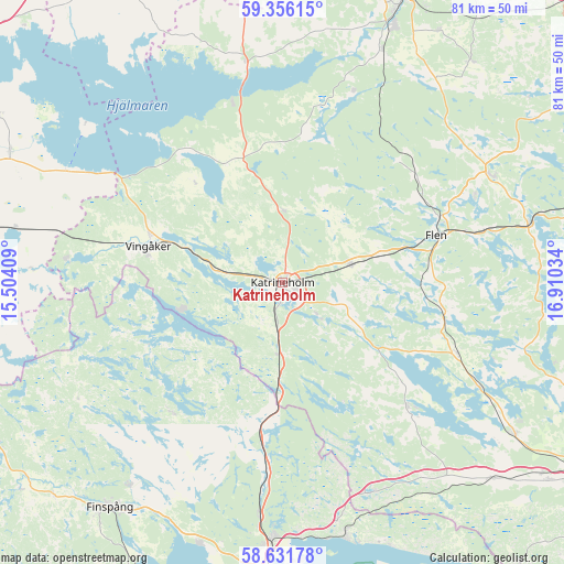
Katrineholm GPS coordinates[2]
58° 59' 45.132" North, 16° 12' 25.956" East
| Map corner | latitude | longitude |
|---|---|---|
| Upper-left | 59.35615°, | 15.50409° |
| Center: | 58.99587°, | 16.20721° |
| Lower-right: | 58.63178°, | 16.91034° |
| Map W x H: | 80.5×80.5 km | = 50×50mi |
| max Lat: | 67.85572° ⇑46.7% North |
| Katrineholm: | 58.99587° |
| min Lat: | ⇓53.3% South 55.34337° |
| min Long | Katrineholm | max Long |
| 11.1712° | 16.20721° | 24.13676° |
| W 64.2%⇐ | ⇒35.8% E |
Elevation
Elevation of Katrineholm is 51 m = 167 ft, and this is 31.6 m = 104 ft below average elevation for this country.
| Max E: |
663 m = 2175 ft | 49.3% |
| Avg. | 82.6 m = 271 ft | |
| Katrineholm | 51 m = 167 ft | |
Min E: |
-1 m = -3 ft | 50.7% |
See also: Sweden elevation on elevation.city.
Geographical zone
Katrineholm is located in North temperate zone (between Tropic of Cancer and the Arctic Circle). Distance of this North polar circle is 841.4 km =522.8 mi to North.| Distance of | km | miles | from Katrineholm |
|---|---|---|---|
| North Pole | 3447.3 | 2142.1 | to North |
| Arctic Circle | 841.4 | 522.8 | to North |
| Tropic Cancer | 3953.8 | 2456.8 | to South |
| Equator | 6559.7 | 4076 | to South |


Nearby cities:
15 places around Katrineholm: (largest is in red/bold)
• Bie
10.3 km =6.4 mi,  0°
0°
• Flen
22.9 km =14.2 mi,  72°
72°
• Forssjö
6.9 km =4.3 mi,  133°
133°
• Hälleforsnäs
24 km =14.9 mi,  43°
43°
• Högsjö
31 km =19.3 mi,  276°
276°
• Malmköping
33.7 km =20.9 mi,  63°
63°
• Mellösa
22.8 km =14.2 mi, 59°
• Olstorp
31.6 km =19.6 mi, 129°
• Rejmyre
24.6 km =15.3 mi,  222°
222°
• Sköldinge
14.3 km =8.9 mi, 74°
• Sparreholm
35.7 km =22.2 mi,  77°
77°
• Strömsfors
35.8 km =22.2 mi,  168°
168°
• Valla
10.3 km =6.4 mi, 77°
• Vingåker
19.8 km =12.3 mi,  285°
285°
• Vrena
32 km =19.9 mi,  117°
117°
Sources, notices
• [Note1] Compared only with cities in Sweden existing in our database
• [Src1] Map data: © OpenStreetMap contributors (CC-BY-SA)
• [Src2] Other city data from geonames.org with taken over terms of usage.
• [Src3] Geographical zone / Annual Mean Temperature by Robert A. Rohde @ Wikipedia
