Vrena geodata
Vrena (Södermanland) is a populated place; located in Sweden in Europe/Stockholm (GMT+2) time zone. With population of 630 people, there are 1145 cities with bigger population in this country. Compared to other cities in Sweden, 52% of cities are located further ↓South; 71.3% of cities are located further ←West and 61.1% of cities have higher elevation than Vrena. Note1
Administrative division(s):
- Level 1: Södermanland
- Level 2: Nyköpings Kommun
- Level 3: Stigtomta-Vrena
- Level 4: Vrena socken


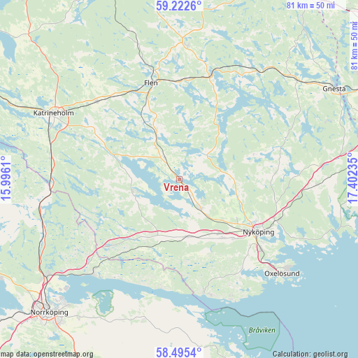
Vrena GPS coordinates[2]
58° 51' 39.276" North, 16° 41' 57.192" East
| Map corner | latitude | longitude |
|---|---|---|
| Upper-left | 59.2226°, | 15.9961° |
| Center: | 58.86091°, | 16.69922° |
| Lower-right: | 58.4954°, | 17.40235° |
| Map W x H: | 80.9×80.9 km | = 50.3×50.3mi |
| max Lat: | 67.85572° ⇑48% North |
| Vrena: | 58.86091° |
| min Lat: | ⇓52% South 55.34337° |
| min Long | Vrena | max Long |
| 11.1712° | 16.69922° | 24.13676° |
| W 71.3%⇐ | ⇒28.7% E |
Elevation
Elevation of Vrena is 34 m = 112 ft, and this is 48.6 m = 159 ft below average elevation for this country.
| Max E: |
663 m = 2175 ft | 61.1% |
| Avg. | 82.6 m = 271 ft | |
| Vrena | 34 m = 112 ft | |
Min E: |
-1 m = -3 ft | 38.9% |
See also: Sweden elevation on elevation.city.
Geographical zone
Vrena is located in North temperate zone (between Tropic of Cancer and the Arctic Circle). Distance of this North polar circle is 856.5 km =532.2 mi to North.| Distance of | km | miles | from Vrena |
|---|---|---|---|
| North Pole | 3462.3 | 2151.4 | to North |
| Arctic Circle | 856.5 | 532.2 | to North |
| Tropic Cancer | 3938.8 | 2447.5 | to South |
| Equator | 6544.7 | 4066.7 | to South |


Nearby cities:
15 places around Vrena: (largest is in red/bold)
• Arnö
23.9 km =14.9 mi,  128°
128°
• Bergshammar
18.2 km =11.3 mi,  137°
137°
• Flen
22.9 km =14.2 mi,  343°
343°
• Forssjö
25.4 km =15.8 mi,  293°
293°
• Jönåker
13 km =8.1 mi,  174°
174°
• Krokek
28.4 km =17.6 mi,  222°
222°
• Mellösa
27.9 km =17.3 mi, 342°
• Nyköping
21.4 km =13.3 mi,  124°
124°
• Nävekvarn
26 km =16.2 mi, 167°
• Olstorp
6.2 km =3.9 mi, 217°
• Sköldinge
23.8 km =14.8 mi,  322°
322°
• Sparreholm
23.8 km =14.8 mi,  16°
16°
• Stigtomta
8.3 km =5.2 mi, 144°
• Svalsta
16.4 km =10.2 mi, 143°
• Valla
25.1 km =15.6 mi,  313°
313°
Sources, notices
• [Note1] Compared only with cities in Sweden existing in our database
• [Src1] Map data: © OpenStreetMap contributors (CC-BY-SA)
• [Src2] Other city data from geonames.org with taken over terms of usage.
• [Src3] Geographical zone / Annual Mean Temperature by Robert A. Rohde @ Wikipedia
