Mellösa geodata
Mellösa (Södermanland) is a populated place; located in Sweden in Europe/Stockholm (GMT+2) time zone. With population of 505 people, there are 1306 cities with bigger population in this country. Compared to other cities in Sweden, 55.2% of cities are located further ↓South; 69.1% of cities are located further ←West and 56.3% of cities have higher elevation than Mellösa. Note1


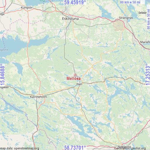
Mellösa GPS coordinates[2]
59° 6' 0" North, 16° 33' 0" East
| Map corner | latitude | longitude |
|---|---|---|
| Upper-left | 59.45919°, | 15.84688° |
| Center: | 59.1°, | 16.55° |
| Lower-right: | 58.73701°, | 17.25313° |
| Map W x H: | 80.3×80.3 km | = 49.9×49.9mi |
| max Lat: | 67.85572° ⇑44.8% North |
| Mellösa: | 59.1° |
| min Lat: | ⇓55.2% South 55.34337° |
| min Long | Mellösa | max Long |
| 11.1712° | 16.55° | 24.13676° |
| W 69.1%⇐ | ⇒30.9% E |
Elevation
Elevation of Mellösa is 40 m = 131 ft, and this is 42.6 m = 140 ft below average elevation for this country.
| Max E: |
663 m = 2175 ft | 56.3% |
| Avg. | 82.6 m = 271 ft | |
| Mellösa | 40 m = 131 ft | |
Min E: |
-1 m = -3 ft | 43.7% |
See also: Sweden elevation on elevation.city.
Geographical zone
Mellösa is located in North temperate zone (between Tropic of Cancer and the Arctic Circle). Distance of this North polar circle is 829.9 km =515.7 mi to North.| Distance of | km | miles | from Mellösa |
|---|---|---|---|
| North Pole | 3435.8 | 2134.9 | to North |
| Arctic Circle | 829.9 | 515.7 | to North |
| Tropic Cancer | 3965.4 | 2464 | to South |
| Equator | 6571.3 | 4083.2 | to South |


Nearby cities:
15 places around Mellösa: (largest is in red/bold)
• Bie
19.5 km =12.1 mi,  266°
266°
• Flen
5.1 km =3.2 mi,  154°
154°
• Forssjö
21.9 km =13.6 mi,  221°
221°
• Hällberga
24.3 km =15.1 mi,  6°
6°
• Hälleforsnäs
6.5 km =4 mi,  332°
332°
• Hållsta
22.3 km =13.9 mi,  345°
345°
• Katrineholm
22.8 km =14.2 mi,  239°
239°
• Malmköping
11.1 km =6.9 mi,  70°
70°
• Skogstorp
25.3 km =15.7 mi, 351°
• Sköldinge
9.7 km =6 mi, 217°
• Sparreholm
15.7 km =9.8 mi,  103°
103°
• Stjärnhov
25.8 km =16 mi,  94°
94°
• Valla
13.3 km =8.3 mi,  225°
225°
• Vrena
27.9 km =17.3 mi,  162°
162°
• Ärla
21.3 km =13.2 mi,  20°
20°
Sources, notices
• [Note1] Compared only with cities in Sweden existing in our database
• [Src1] Map data: © OpenStreetMap contributors (CC-BY-SA)
• [Src2] Other city data from geonames.org with taken over terms of usage.
• [Src3] Geographical zone / Annual Mean Temperature by Robert A. Rohde @ Wikipedia
