Motala geodata
Motala (Östergötland) is a seat of a second-order administrative division; located in Sweden in Europe/Stockholm (GMT+2) time zone. With population of 30,944 people, there are 52 cities with bigger population in this country. Compared to other cities in Sweden, 52% of cities are located further ↑North; 50.2% of cities are located further →East and 72.3% of cities have lower elevation than Motala. Note1


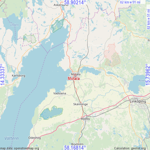
Motala GPS coordinates[2]
58° 32' 13.416" North, 15° 2' 11.364" East
| Map corner | latitude | longitude |
|---|---|---|
| Upper-left | 58.90214°, | 14.33337° |
| Center: | 58.53706°, | 15.03649° |
| Lower-right: | 58.16814°, | 15.73962° |
| Map W x H: | 81.6×81.6 km | = 50.7×50.7mi |
| max Lat: | 67.85572° ⇑52% North |
| Motala: | 58.53706° |
| min Lat: | ⇓48% South 55.34337° |
| min Long | Motala | max Long |
| 11.1712° | 15.03649° | 24.13676° |
| W 49.8%⇐ | ⇒50.2% E |
Elevation
Elevation of Motala is 107 m = 351 ft, and this is 24.4 m = 80 ft above average elevation for this country.
| Max E: |
663 m = 2175 ft | 27.7% |
| Motala | 107 m 351 ft | |
| Avg. | 82.6 m = 271 ft | |
Min E: |
-1 m = -3 ft | 72.3% |
See also: Sweden elevation on elevation.city.
Geographical zone
Motala is located in North temperate zone (between Tropic of Cancer and the Arctic Circle). Distance of this North polar circle is 892.5 km =554.6 mi to North.| Distance of | km | miles | from Motala |
|---|---|---|---|
| North Pole | 3498.4 | 2173.8 | to North |
| Arctic Circle | 892.5 | 554.6 | to North |
| Tropic Cancer | 3902.8 | 2425.1 | to South |
| Equator | 6508.7 | 4044.3 | to South |


Nearby cities:
15 places around Motala: (largest is in red/bold)
• Berg
29.2 km =18.1 mi,  100°
100°
• Borensberg
14.7 km =9.1 mi,  77°
77°
• Herrestad
21.9 km =13.6 mi,  218°
218°
• Karlsborg
30.9 km =19.2 mi,  270°
270°
• Ljungsbro
27 km =16.8 mi,  94°
94°
• Malmslätt
31.2 km =19.4 mi,  116°
116°
• Mantorp
25.3 km =15.7 mi,  145°
145°
• Mjölby
24 km =14.9 mi,  167°
167°
• Ryd
14.7 km =9.1 mi,  10°
10°
• Skänninge
16.1 km =10 mi, 169°
• Stenstorp
6.2 km =3.9 mi,  163°
163°
• Tjällmo
27 km =16.8 mi,  42°
42°
• Vadstena
13 km =8.1 mi, 220°
• Vikingstad
28.7 km =17.8 mi,  126°
126°
• Väderstad
25.5 km =15.8 mi,  195°
195°
Sources, notices
• [Note1] Compared only with cities in Sweden existing in our database
• [Src1] Map data: © OpenStreetMap contributors (CC-BY-SA)
• [Src2] Other city data from geonames.org with taken over terms of usage.
• [Src3] Geographical zone / Annual Mean Temperature by Robert A. Rohde @ Wikipedia
