Korsberga geodata
Korsberga (Jönköping) is a populated place; located in Sweden in Europe/Stockholm (GMT+2) time zone. With population of 731 people, there are 1031 cities with bigger population in this country. Compared to other cities in Sweden, 74.8% of cities are located further ↑North; 51.3% of cities are located further ←West and 94.1% of cities have lower elevation than Korsberga. Note1


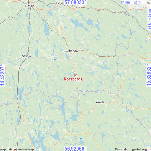
Korsberga GPS coordinates[2]
57° 18' 8.856" North, 15° 7' 30.684" East
| Map corner | latitude | longitude |
|---|---|---|
| Upper-left | 57.68033°, | 14.42207° |
| Center: | 57.30246°, | 15.12519° |
| Lower-right: | 56.92066°, | 15.82832° |
| Map W x H: | 84.5×84.5 km | = 52.5×52.5mi |
| max Lat: | 67.85572° ⇑74.8% North |
| Korsberga: | 57.30246° |
| min Lat: | ⇓25.2% South 55.34337° |
| min Long | Korsberga | max Long |
| 11.1712° | 15.12519° | 24.13676° |
| W 51.3%⇐ | ⇒48.7% E |
Elevation
Elevation of Korsberga is 243 m = 797 ft, and this is 160.4 m = 526 ft above average elevation for this country.
| Max E: |
663 m = 2175 ft | 5.9% |
| Korsberga | 243 m 797 ft | |
| Avg. | 82.6 m = 271 ft | |
Min E: |
-1 m = -3 ft | 94.1% |
See also: Sweden elevation on elevation.city.
Geographical zone
Korsberga is located in North temperate zone (between Tropic of Cancer and the Arctic Circle). Distance of this North polar circle is 1029.7 km =639.8 mi to North.| Distance of | km | miles | from Korsberga |
|---|---|---|---|
| North Pole | 3635.6 | 2259.1 | to North |
| Arctic Circle | 1029.7 | 639.8 | to North |
| Tropic Cancer | 3765.5 | 2339.8 | to South |
| Equator | 6371.4 | 3959 | to South |


Nearby cities:
15 places around Korsberga: (largest is in red/bold)
• Bodafors
33.6 km =20.9 mi,  310°
310°
• Braås
26.6 km =16.5 mi,  189°
189°
• Burseryd
21.7 km =13.5 mi,  289°
289°
• Ekenässjön
21.9 km =13.6 mi,  343°
343°
• Holsbybrunn
15.2 km =9.4 mi,  17°
17°
• Hällaryd
18.4 km =11.4 mi,  7°
7°
• Järnforsen
32.1 km =19.9 mi,  66°
66°
• Landsbro
15.3 km =9.5 mi,  297°
297°
• Myresjö
13.4 km =8.3 mi, 313°
• Skruv
17.1 km =10.6 mi,  171°
171°
• Stockaryd
32 km =19.9 mi,  272°
272°
• Sävsjö
29.9 km =18.6 mi, 291°
• Vetlanda
14.3 km =8.9 mi,  348°
348°
• Virserum
27.6 km =17.1 mi,  86°
86°
• Åseda
19.8 km =12.3 mi,  138°
138°
Sources, notices
• [Note1] Compared only with cities in Sweden existing in our database
• [Src1] Map data: © OpenStreetMap contributors (CC-BY-SA)
• [Src2] Other city data from geonames.org with taken over terms of usage.
• [Src3] Geographical zone / Annual Mean Temperature by Robert A. Rohde @ Wikipedia
