Söderfors geodata
Söderfors (Västerbotten) is a populated place; located in Sweden in Europe/Stockholm (GMT+2) time zone. With population of 1,597 people, there are 623 cities with bigger population in this country. Compared to other cities in Sweden, 94.9% of cities are located further ↓South; 86.1% of cities are located further ←West and 95.3% of cities have lower elevation than Söderfors. Note1


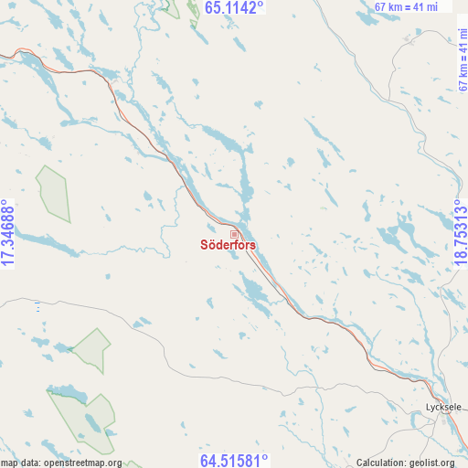
Söderfors GPS coordinates[2]
64° 49' 0.012" North, 18° 3' 0" East
| Map corner | latitude | longitude |
|---|---|---|
| Upper-left | 65.1142°, | 17.34688° |
| Center: | 64.81667°, | 18.05° |
| Lower-right: | 64.51581°, | 18.75313° |
| Map W x H: | 66.5×66.5 km | = 41.3×41.3mi |
| max Lat: | 67.85572° ⇑5.1% North |
| Söderfors: | 64.81667° |
| min Lat: | ⇓94.9% South 55.34337° |
| min Long | Söderfors | max Long |
| 11.1712° | 18.05° | 24.13676° |
| W 86.1%⇐ | ⇒13.9% E |
Elevation
Elevation of Söderfors is 273 m = 896 ft, and this is 190.4 m = 625 ft above average elevation for this country.
| Max E: |
663 m = 2175 ft | 4.7% |
| Söderfors | 273 m 896 ft | |
| Avg. | 82.6 m = 271 ft | |
Min E: |
-1 m = -3 ft | 95.3% |
See also: Sweden elevation on elevation.city.
Geographical zone
Söderfors is located in North temperate zone (between Tropic of Cancer and the Arctic Circle). Distance of this North polar circle is 194.2 km =120.7 mi to North.| Distance of | km | miles | from Söderfors |
|---|---|---|---|
| North Pole | 2800.1 | 1739.9 | to North |
| Arctic Circle | 194.2 | 120.7 | to North |
| Tropic Cancer | 4601 | 2858.9 | to South |
| Equator | 7206.9 | 4478.2 | to South |


Nearby cities:
15 places around Söderfors: (largest is in red/bold)
• Arvidsjaur
100.6 km =62.5 mi,  31°
31°
• Dorotea
99.6 km =61.9 mi,  231°
231°
• Guojkkasuoluoj
92.4 km =57.4 mi,  1°
1°
• Insjön
53.6 km =33.3 mi,  210°
210°
• Jörn
97.5 km =60.6 mi,  73°
73°
• Lycksele
38.5 km =23.9 mi,  129°
129°
• Långsele
104.1 km =64.7 mi,  90°
90°
• Malå
52.3 km =32.5 mi,  38°
38°
• Norsjö
68.4 km =42.5 mi,  81°
81°
• Sorsele
83.4 km =51.8 mi,  343°
343°
• Storuman
53.8 km =33.4 mi,  305°
305°
• Sunnansjö
101.2 km =62.9 mi,  141°
141°
• Tallåsen
68.6 km =42.6 mi,  146°
146°
• Vilhelmina
69.6 km =43.2 mi,  252°
252°
• Åsele
80.4 km =50 mi,  204°
204°
Sources, notices
• [Note1] Compared only with cities in Sweden existing in our database
• [Src1] Map data: © OpenStreetMap contributors (CC-BY-SA)
• [Src2] Other city data from geonames.org with taken over terms of usage.
• [Src3] Geographical zone / Annual Mean Temperature by Robert A. Rohde @ Wikipedia
