Nykroppa geodata
Nykroppa (Värmland) is a populated place; located in Sweden in Europe/Stockholm (GMT+2) time zone. With population of 788 people, there are 974 cities with bigger population in this country. Compared to other cities in Sweden, 68.8% of cities are located further ↓South; 59.1% of cities are located further →East and 80.4% of cities have lower elevation than Nykroppa. Note1
Administrative division(s):
- Level 1: Värmland
- Level 2: Filipstads Kommun
- Level 3: Kroppa
- Level 4: Kroppa socken


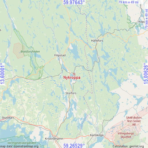
Nykroppa GPS coordinates[2]
59° 37' 21.864" North, 14° 18' 11.268" East
| Map corner | latitude | longitude |
|---|---|---|
| Upper-left | 59.97643°, | 13.60001° |
| Center: | 59.62274°, | 14.30313° |
| Lower-right: | 59.26529°, | 15.00626° |
| Map W x H: | 79.1×79.1 km | = 49.2×49.2mi |
| max Lat: | 67.85572° ⇑31.2% North |
| Nykroppa: | 59.62274° |
| min Lat: | ⇓68.8% South 55.34337° |
| min Long | Nykroppa | max Long |
| 11.1712° | 14.30313° | 24.13676° |
| W 40.9%⇐ | ⇒59.1% E |
Elevation
Elevation of Nykroppa is 147 m = 482 ft, and this is 64.4 m = 211 ft above average elevation for this country.
| Max E: |
663 m = 2175 ft | 19.6% |
| Nykroppa | 147 m 482 ft | |
| Avg. | 82.6 m = 271 ft | |
Min E: |
-1 m = -3 ft | 80.4% |
See also: Sweden elevation on elevation.city.
Geographical zone
Nykroppa is located in North temperate zone (between Tropic of Cancer and the Arctic Circle). Distance of this North polar circle is 771.7 km =479.5 mi to North.| Distance of | km | miles | from Nykroppa |
|---|---|---|---|
| North Pole | 3377.6 | 2098.7 | to North |
| Arctic Circle | 771.7 | 479.5 | to North |
| Tropic Cancer | 4023.5 | 2500.1 | to South |
| Equator | 6629.4 | 4119.3 | to South |


Nearby cities:
15 places around Nykroppa: (largest is in red/bold)
• Björneborg
42.5 km =26.4 mi,  184°
184°
• Degerfors
43.4 km =27 mi,  170°
170°
• Filipstad
12.5 km =7.8 mi,  322°
322°
• Grythyttan
16 km =9.9 mi,  54°
54°
• Gyttorp
39.6 km =24.6 mi,  109°
109°
• Hällefors
21.7 km =13.5 mi,  34°
34°
• Karlskoga
35.2 km =21.9 mi,  159°
159°
• Kristinehamn
36.5 km =22.7 mi,  197°
197°
• Lesjöfors
39.8 km =24.7 mi,  350°
350°
• Molkom
32.8 km =20.4 mi,  265°
265°
• Nora
43.1 km =26.8 mi, 105°
• Sjötorp
15.8 km =9.8 mi,  190°
190°
• Skattkärr
42.7 km =26.5 mi,  236°
236°
• Storfors
10.3 km =6.4 mi, 189°
• Väse
36.9 km =22.9 mi,  223°
223°
Sources, notices
• [Note1] Compared only with cities in Sweden existing in our database
• [Src1] Map data: © OpenStreetMap contributors (CC-BY-SA)
• [Src2] Other city data from geonames.org with taken over terms of usage.
• [Src3] Geographical zone / Annual Mean Temperature by Robert A. Rohde @ Wikipedia
