Silverdalen geodata
Silverdalen (Kalmar) is a populated place; located in Sweden in Europe/Stockholm (GMT+2) time zone. With population of 681 people, there are 1088 cities with bigger population in this country. Compared to other cities in Sweden, 71.1% of cities are located further ↑North; 58.8% of cities are located further ←West and 75.9% of cities have lower elevation than Silverdalen. Note1


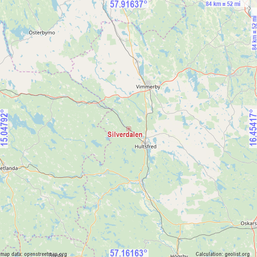
Silverdalen GPS coordinates[2]
57° 32' 27.42" North, 15° 45' 3.744" East
| Map corner | latitude | longitude |
|---|---|---|
| Upper-left | 57.91637°, | 15.04792° |
| Center: | 57.54095°, | 15.75104° |
| Lower-right: | 57.16163°, | 16.45417° |
| Map W x H: | 83.9×83.9 km | = 52.1×52.1mi |
| max Lat: | 67.85572° ⇑71.1% North |
| Silverdalen: | 57.54095° |
| min Lat: | ⇓28.9% South 55.34337° |
| min Long | Silverdalen | max Long |
| 11.1712° | 15.75104° | 24.13676° |
| W 58.8%⇐ | ⇒41.2% E |
Elevation
Elevation of Silverdalen is 124 m = 407 ft, and this is 41.4 m = 136 ft above average elevation for this country.
| Max E: |
663 m = 2175 ft | 24.1% |
| Silverdalen | 124 m 407 ft | |
| Avg. | 82.6 m = 271 ft | |
Min E: |
-1 m = -3 ft | 75.9% |
See also: Sweden elevation on elevation.city.
Geographical zone
Silverdalen is located in North temperate zone (between Tropic of Cancer and the Arctic Circle). Distance of this North polar circle is 1003.2 km =623.4 mi to North.| Distance of | km | miles | from Silverdalen |
|---|---|---|---|
| North Pole | 3609.1 | 2242.6 | to North |
| Arctic Circle | 1003.2 | 623.4 | to North |
| Tropic Cancer | 3792 | 2356.2 | to South |
| Equator | 6398 | 3975.5 | to South |


Nearby cities:
15 places around Silverdalen: (largest is in red/bold)
• Ankarsrum
38.9 km =24.2 mi,  63°
63°
• Berga
39.8 km =24.7 mi,  154°
154°
• Gullringen
29 km =18 mi,  353°
353°
• Holsbybrunn
35 km =21.7 mi,  250°
250°
• Hultsfred
8.1 km =5 mi,  136°
136°
• Hällaryd
35.9 km =22.3 mi,  256°
256°
• Järnforsen
16 km =9.9 mi,  210°
210°
• Kristdala
31.3 km =19.4 mi,  119°
119°
• Mariannelund
13.8 km =8.6 mi,  307°
307°
• Målilla
17.4 km =10.8 mi,  168°
168°
• Mörlunda
25.6 km =15.9 mi, 166°
• Storebro
7.6 km =4.7 mi,  51°
51°
• Södra Vi
22.3 km =13.9 mi,  6°
6°
• Vimmerby
15.2 km =9.4 mi,  24°
24°
• Virserum
26.9 km =16.7 mi,  201°
201°
Sources, notices
• [Note1] Compared only with cities in Sweden existing in our database
• [Src1] Map data: © OpenStreetMap contributors (CC-BY-SA)
• [Src2] Other city data from geonames.org with taken over terms of usage.
• [Src3] Geographical zone / Annual Mean Temperature by Robert A. Rohde @ Wikipedia
