Funäsdalen geodata
Funäsdalen (Jämtland) is a populated place; located in Sweden in Europe/Stockholm (GMT+2) time zone. With population of 956 people, there are 844 cities with bigger population in this country. Compared to other cities in Sweden, 87.8% of cities are located further ↓South; 87.9% of cities are located further →East and 100% of cities have lower elevation than Funäsdalen. Note1


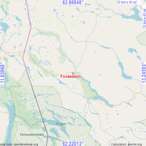
Funäsdalen GPS coordinates[2]
62° 32' 45.852" North, 12° 32' 34.08" East
| Map corner | latitude | longitude |
|---|---|---|
| Upper-left | 62.86848°, | 11.83968° |
| Center: | 62.54607°, | 12.5428° |
| Lower-right: | 62.22013°, | 13.24593° |
| Map W x H: | 72.1×72.1 km | = 44.8×44.8mi |
| max Lat: | 67.85572° ⇑12.2% North |
| Funäsdalen: | 62.54607° |
| min Lat: | ⇓87.8% South 55.34337° |
| min Long | Funäsdalen | max Long |
| 11.1712° | 12.5428° | 24.13676° |
| W 12.1%⇐ | ⇒87.9% E |
Elevation
Elevation of Funäsdalen is 663 m = 2175 ft, and this is 580.4 m = 1904 ft above average elevation for this country.
| Max E: |
663 m = 2175 ft | 0% |
| Funäsdalen | 663 m 2175 ft | |
| Avg. | 82.6 m = 271 ft | |
Min E: |
-1 m = -3 ft | 100% |
See also: Sweden elevation on elevation.city.
Geographical zone
Funäsdalen is located in North temperate zone (between Tropic of Cancer and the Arctic Circle). Distance of this North polar circle is 446.7 km =277.6 mi to North.| Distance of | km | miles | from Funäsdalen |
|---|---|---|---|
| North Pole | 3052.6 | 1896.8 | to North |
| Arctic Circle | 446.7 | 277.6 | to North |
| Tropic Cancer | 4348.6 | 2702.1 | to South |
| Equator | 6954.5 | 4321.3 | to South |


Nearby cities:
15 places around Funäsdalen: (largest is in red/bold)
• Björnänge
97.8 km =60.8 mi,  17°
17°
• Duved
96.3 km =59.8 mi,  9°
9°
• Hackås
108.7 km =67.5 mi,  67°
67°
• Hede
52 km =32.3 mi,  106°
106°
• Hoverberg
101.6 km =63.1 mi, 72°
• Idre
77 km =47.8 mi,  173°
173°
• Järpen
100.5 km =62.4 mi,  27°
27°
• Mörsil
102 km =63.4 mi, 33°
• Nälden
124.3 km =77.2 mi,  44°
44°
• Sveg
110.1 km =68.4 mi,  121°
121°
• Svenstavik
99.7 km =62 mi,  75°
75°
• Särna
99.9 km =62.1 mi,  161°
161°
• Undersåker
92.9 km =57.7 mi, 22°
• Vemdalen
68.8 km =42.8 mi,  98°
98°
• Åre
98.7 km =61.3 mi, 15°
Sources, notices
• [Note1] Compared only with cities in Sweden existing in our database
• [Src1] Map data: © OpenStreetMap contributors (CC-BY-SA)
• [Src2] Other city data from geonames.org with taken over terms of usage.
• [Src3] Geographical zone / Annual Mean Temperature by Robert A. Rohde @ Wikipedia
