Finnerödja geodata
Finnerödja (Örebro) is a populated place; located in Sweden in Europe/Stockholm (GMT+2) time zone. With population of 575 people, there are 1201 cities with bigger population in this country. Compared to other cities in Sweden, 52.6% of cities are located further ↓South; 58.1% of cities are located further →East and 69.3% of cities have lower elevation than Finnerödja. Note1


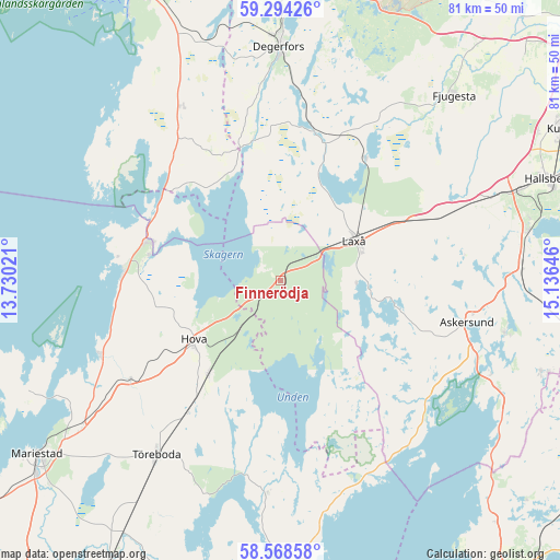
Finnerödja GPS coordinates[2]
58° 55' 59.988" North, 14° 25' 59.988" East
| Map corner | latitude | longitude |
|---|---|---|
| Upper-left | 59.29426°, | 13.73021° |
| Center: | 58.93333°, | 14.43333° |
| Lower-right: | 58.56858°, | 15.13646° |
| Map W x H: | 80.7×80.7 km | = 50.1×50.1mi |
| max Lat: | 67.85572° ⇑47.4% North |
| Finnerödja: | 58.93333° |
| min Lat: | ⇓52.6% South 55.34337° |
| min Long | Finnerödja | max Long |
| 11.1712° | 14.43333° | 24.13676° |
| W 41.9%⇐ | ⇒58.1% E |
Elevation
Elevation of Finnerödja is 97 m = 318 ft, and this is 14.4 m = 47 ft above average elevation for this country.
| Max E: |
663 m = 2175 ft | 30.7% |
| Finnerödja | 97 m 318 ft | |
| Avg. | 82.6 m = 271 ft | |
Min E: |
-1 m = -3 ft | 69.3% |
See also: Sweden elevation on elevation.city.
Geographical zone
Finnerödja is located in North temperate zone (between Tropic of Cancer and the Arctic Circle). Distance of this North polar circle is 848.4 km =527.2 mi to North.| Distance of | km | miles | from Finnerödja |
|---|---|---|---|
| North Pole | 3454.3 | 2146.4 | to North |
| Arctic Circle | 848.4 | 527.2 | to North |
| Tropic Cancer | 3946.9 | 2452.5 | to South |
| Equator | 6552.8 | 4071.7 | to South |


Nearby cities:
15 places around Finnerödja: (largest is in red/bold)
• Anderstorp
10.3 km =6.4 mi,  237°
237°
• Askersund
27.6 km =17.1 mi,  102°
102°
• Baggetorp
26.7 km =16.6 mi,  25°
25°
• Björneborg
35.8 km =22.2 mi,  342°
342°
• Degerfors
33.9 km =21.1 mi,  359°
359°
• Fjugesta
36.7 km =22.8 mi,  43°
43°
• Gullspång
20.2 km =12.6 mi,  286°
286°
• Hova
15.2 km =9.4 mi,  234°
234°
• Laxå
12.2 km =7.6 mi,  61°
61°
• Mullhyttan
28 km =17.4 mi, 30°
• Otterbäcken
23 km =14.3 mi,  274°
274°
• Töreboda
30.7 km =19.1 mi,  215°
215°
• Vretstorp
27.2 km =16.9 mi,  65°
65°
• Åsbro
36.1 km =22.4 mi,  78°
78°
• Östansjö
34.1 km =21.2 mi, 67°
Sources, notices
• [Note1] Compared only with cities in Sweden existing in our database
• [Src1] Map data: © OpenStreetMap contributors (CC-BY-SA)
• [Src2] Other city data from geonames.org with taken over terms of usage.
• [Src3] Geographical zone / Annual Mean Temperature by Robert A. Rohde @ Wikipedia
