Björneborg geodata
Björneborg (Värmland) is a populated place; located in Sweden in Europe/Stockholm (GMT+2) time zone. With population of 1,237 people, there are 730 cities with bigger population in this country. Compared to other cities in Sweden, 57.8% of cities are located further ↓South; 60.3% of cities are located further →East and 75.7% of cities have lower elevation than Björneborg. Note1


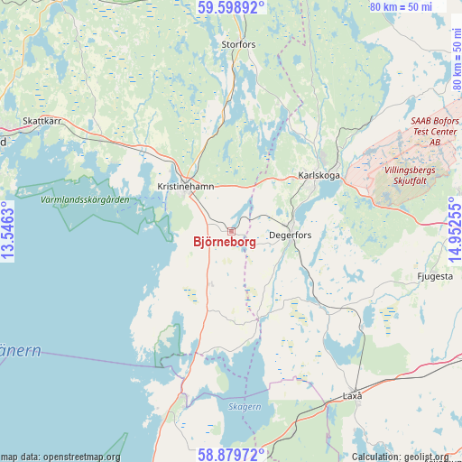
Björneborg GPS coordinates[2]
59° 14' 28.392" North, 14° 14' 57.912" East
| Map corner | latitude | longitude |
|---|---|---|
| Upper-left | 59.59892°, | 13.5463° |
| Center: | 59.24122°, | 14.24942° |
| Lower-right: | 58.87972°, | 14.95255° |
| Map W x H: | 80×80 km | = 49.7×49.7mi |
| max Lat: | 67.85572° ⇑42.2% North |
| Björneborg: | 59.24122° |
| min Lat: | ⇓57.8% South 55.34337° |
| min Long | Björneborg | max Long |
| 11.1712° | 14.24942° | 24.13676° |
| W 39.7%⇐ | ⇒60.3% E |
Elevation
Elevation of Björneborg is 123 m = 404 ft, and this is 40.4 m = 133 ft above average elevation for this country.
| Max E: |
663 m = 2175 ft | 24.3% |
| Björneborg | 123 m 404 ft | |
| Avg. | 82.6 m = 271 ft | |
Min E: |
-1 m = -3 ft | 75.7% |
See also: Sweden elevation on elevation.city.
Geographical zone
Björneborg is located in North temperate zone (between Tropic of Cancer and the Arctic Circle). Distance of this North polar circle is 814.2 km =505.9 mi to North.| Distance of | km | miles | from Björneborg |
|---|---|---|---|
| North Pole | 3420.1 | 2125.2 | to North |
| Arctic Circle | 814.2 | 505.9 | to North |
| Tropic Cancer | 3981.1 | 2473.7 | to South |
| Equator | 6587 | 4093 | to South |


Nearby cities:
15 places around Björneborg: (largest is in red/bold)
• Baggetorp
24.1 km =15 mi,  114°
114°
• Degerfors
10.3 km =6.4 mi,  92°
92°
• Finnerödja
35.8 km =22.2 mi,  162°
162°
• Fjugesta
36.2 km =22.5 mi,  101°
101°
• Gullspång
29.7 km =18.5 mi,  197°
197°
• Karlskoga
18.3 km =11.4 mi,  58°
58°
• Kristinehamn
11.1 km =6.9 mi,  313°
313°
• Laxå
35.3 km =21.9 mi,  143°
143°
• Mullhyttan
26.7 km =16.6 mi, 112°
• Otterbäcken
34.7 km =21.6 mi, 200°
• Sjötorp
26.9 km =16.7 mi,  0°
0°
• Skattkärr
37.9 km =23.5 mi,  300°
300°
• Storfors
32.3 km =20.1 mi, 2°
• Vintrosa
39.8 km =24.7 mi, 88°
• Väse
27.5 km =17.1 mi, 304°
Sources, notices
• [Note1] Compared only with cities in Sweden existing in our database
• [Src1] Map data: © OpenStreetMap contributors (CC-BY-SA)
• [Src2] Other city data from geonames.org with taken over terms of usage.
• [Src3] Geographical zone / Annual Mean Temperature by Robert A. Rohde @ Wikipedia
