Hova geodata
Hova (Västra Götaland) is a seat of a second-order administrative division; located in Sweden in Europe/Stockholm (GMT+2) time zone. With population of 1,254 people, there are 725 cities with bigger population in this country. Compared to other cities in Sweden, 51.9% of cities are located further ↓South; 60.6% of cities are located further →East and 73.7% of cities have lower elevation than Hova. Note1
Administrative division(s):
- Level 1: Västra Götaland
- Level 2: Gullspångs Kommun
- Level 3: Hova-Älgarås, del
- Level 4: Hova socken


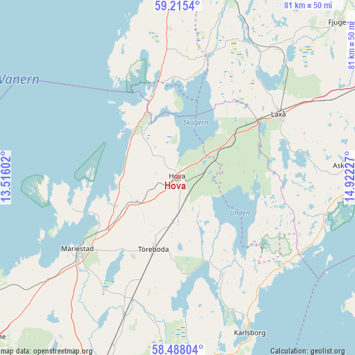
Hova GPS coordinates[2]
58° 51' 13.068" North, 14° 13' 8.904" East
| Map corner | latitude | longitude |
|---|---|---|
| Upper-left | 59.2154°, | 13.51602° |
| Center: | 58.85363°, | 14.21914° |
| Lower-right: | 58.48804°, | 14.92227° |
| Map W x H: | 80.9×80.9 km | = 50.3×50.3mi |
| max Lat: | 67.85572° ⇑48.1% North |
| Hova: | 58.85363° |
| min Lat: | ⇓51.9% South 55.34337° |
| min Long | Hova | max Long |
| 11.1712° | 14.21914° | 24.13676° |
| W 39.4%⇐ | ⇒60.6% E |
Elevation
Elevation of Hova is 112 m = 367 ft, and this is 29.4 m = 96 ft above average elevation for this country.
| Max E: |
663 m = 2175 ft | 26.3% |
| Hova | 112 m 367 ft | |
| Avg. | 82.6 m = 271 ft | |
Min E: |
-1 m = -3 ft | 73.7% |
See also: Sweden elevation on elevation.city.
Geographical zone
Hova is located in North temperate zone (between Tropic of Cancer and the Arctic Circle). Distance of this North polar circle is 857.3 km =532.7 mi to North.| Distance of | km | miles | from Hova |
|---|---|---|---|
| North Pole | 3463.2 | 2151.9 | to North |
| Arctic Circle | 857.3 | 532.7 | to North |
| Tropic Cancer | 3938 | 2447 | to South |
| Equator | 6543.9 | 4066.2 | to South |


Nearby cities:
15 places around Hova: (largest is in red/bold)
• Anderstorp
5 km =3.1 mi,  48°
48°
• Askersund
39.4 km =24.5 mi,  85°
85°
• Baggetorp
40.6 km =25.2 mi,  35°
35°
• Finnerödja
15.2 km =9.4 mi, 54°
• Gullspång
16.3 km =10.1 mi,  334°
334°
• Karlsborg
38.9 km =24.2 mi,  154°
154°
• Laxå
27.3 km =17 mi,  57°
57°
• Lugnås
37.9 km =23.5 mi,  231°
231°
• Mariestad
27.8 km =17.3 mi, 234°
• Moholm
29.4 km =18.3 mi,  200°
200°
• Mölltorp
40.7 km =25.3 mi,  165°
165°
• Otterbäcken
15.1 km =9.4 mi,  315°
315°
• Tidan
33.4 km =20.8 mi, 201°
• Töreboda
17.1 km =10.6 mi, 198°
• Ullervad
29.1 km =18.1 mi,  224°
224°
Sources, notices
• [Note1] Compared only with cities in Sweden existing in our database
• [Src1] Map data: © OpenStreetMap contributors (CC-BY-SA)
• [Src2] Other city data from geonames.org with taken over terms of usage.
• [Src3] Geographical zone / Annual Mean Temperature by Robert A. Rohde @ Wikipedia
