Gullspång geodata
Gullspång (Västra Götaland) is a populated place; located in Sweden in Europe/Stockholm (GMT+2) time zone. With population of 1,568 people, there are 633 cities with bigger population in this country. Compared to other cities in Sweden, 53.2% of cities are located further ↓South; 63.1% of cities are located further →East and 54.4% of cities have lower elevation than Gullspång. Note1


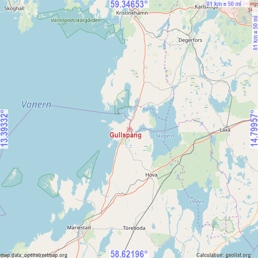
Gullspång GPS coordinates[2]
58° 59' 10.14" North, 14° 5' 47.184" East
| Map corner | latitude | longitude |
|---|---|---|
| Upper-left | 59.34653°, | 13.39332° |
| Center: | 58.98615°, | 14.09644° |
| Lower-right: | 58.62196°, | 14.79957° |
| Map W x H: | 80.6×80.6 km | = 50.1×50.1mi |
| max Lat: | 67.85572° ⇑46.8% North |
| Gullspång: | 58.98615° |
| min Lat: | ⇓53.2% South 55.34337° |
| min Long | Gullspång | max Long |
| 11.1712° | 14.09644° | 24.13676° |
| W 36.9%⇐ | ⇒63.1% E |
Elevation
Elevation of Gullspång is 58 m = 190 ft, and this is 24.6 m = 81 ft below average elevation for this country.
| Max E: |
663 m = 2175 ft | 45.6% |
| Avg. | 82.6 m = 271 ft | |
| Gullspång | 58 m = 190 ft | |
Min E: |
-1 m = -3 ft | 54.4% |
See also: Sweden elevation on elevation.city.
Geographical zone
Gullspång is located in North temperate zone (between Tropic of Cancer and the Arctic Circle). Distance of this North polar circle is 842.5 km =523.5 mi to North.| Distance of | km | miles | from Gullspång |
|---|---|---|---|
| North Pole | 3448.4 | 2142.7 | to North |
| Arctic Circle | 842.5 | 523.5 | to North |
| Tropic Cancer | 3952.7 | 2456.1 | to South |
| Equator | 6558.6 | 4075.3 | to South |


Nearby cities:
15 places around Gullspång: (largest is in red/bold)
• Anderstorp
15.7 km =9.8 mi,  136°
136°
• Baggetorp
35.7 km =22.2 mi,  59°
59°
• Björneborg
29.7 km =18.5 mi,  17°
17°
• Degerfors
33.9 km =21.1 mi,  34°
34°
• Finnerödja
20.2 km =12.6 mi,  106°
106°
• Hova
16.3 km =10.1 mi,  154°
154°
• Kristinehamn
36 km =22.4 mi,  1°
1°
• Laxå
29.9 km =18.6 mi,  89°
89°
• Mariestad
34.5 km =21.4 mi,  207°
207°
• Moholm
42.3 km =26.3 mi,  184°
184°
• Mullhyttan
38.2 km =23.7 mi, 61°
• Otterbäcken
5.4 km =3.4 mi,  221°
221°
• Töreboda
31 km =19.3 mi, 176°
• Ullervad
37.9 km =23.5 mi,  200°
200°
• Vretstorp
44.4 km =27.6 mi,  83°
83°
Sources, notices
• [Note1] Compared only with cities in Sweden existing in our database
• [Src1] Map data: © OpenStreetMap contributors (CC-BY-SA)
• [Src2] Other city data from geonames.org with taken over terms of usage.
• [Src3] Geographical zone / Annual Mean Temperature by Robert A. Rohde @ Wikipedia
