Vänersborg geodata
Vänersborg (Västra Götaland) is a seat of a second-order administrative division; located in Sweden in Europe/Stockholm (GMT+2) time zone. With population of 23,119 people, there are 69 cities with bigger population in this country. Compared to other cities in Sweden, 55.2% of cities are located further ↑North; 90.2% of cities are located further →East and 52.1% of cities have lower elevation than Vänersborg. Note1


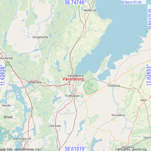
Vänersborg GPS coordinates[2]
58° 22' 50.7" North, 12° 19' 24.24" East
| Map corner | latitude | longitude |
|---|---|---|
| Upper-left | 58.74746°, | 11.62028° |
| Center: | 58.38075°, | 12.3234° |
| Lower-right: | 58.01019°, | 13.02653° |
| Map W x H: | 82×82 km | = 51×51mi |
| max Lat: | 67.85572° ⇑55.2% North |
| Vänersborg: | 58.38075° |
| min Lat: | ⇓44.8% South 55.34337° |
| min Long | Vänersborg | max Long |
| 11.1712° | 12.3234° | 24.13676° |
| W 9.8%⇐ | ⇒90.2% E |
Elevation
Elevation of Vänersborg is 54 m = 177 ft, and this is 28.6 m = 94 ft below average elevation for this country.
| Max E: |
663 m = 2175 ft | 47.9% |
| Avg. | 82.6 m = 271 ft | |
| Vänersborg | 54 m = 177 ft | |
Min E: |
-1 m = -3 ft | 52.1% |
See also: Sweden elevation on elevation.city.
Geographical zone
Vänersborg is located in North temperate zone (between Tropic of Cancer and the Arctic Circle). Distance of this North polar circle is 909.8 km =565.3 mi to North.| Distance of | km | miles | from Vänersborg |
|---|---|---|---|
| North Pole | 3515.7 | 2184.6 | to North |
| Arctic Circle | 909.8 | 565.3 | to North |
| Tropic Cancer | 3885.4 | 2414.3 | to South |
| Equator | 6491.3 | 4033.5 | to South |


Nearby cities:
15 places around Vänersborg: (largest is in red/bold)
• Ammenäs
29.9 km =18.6 mi,  255°
255°
• Brålanda
20.4 km =12.7 mi,  4°
4°
• Frändefors
13.5 km =8.4 mi,  350°
350°
• Färgelanda
28.4 km =17.6 mi,  317°
317°
• Grästorp
21.6 km =13.4 mi,  104°
104°
• Lilla Edet
29.7 km =18.5 mi,  202°
202°
• Ljungskile
29.3 km =18.2 mi,  233°
233°
• Sjuntorp
21 km =13 mi, 197°
• Sunningen
29.1 km =18.1 mi, 259°
• Trollhättan
11 km =6.8 mi,  190°
190°
• Uddevalla
22.5 km =14 mi, 260°
• Upphärad
24.8 km =15.4 mi,  182°
182°
• Vargön
4.8 km =3 mi,  125°
125°
• Velanda
16.9 km =10.5 mi, 182°
• Ödeborg
27.3 km =17 mi,  312°
312°
Sources, notices
• [Note1] Compared only with cities in Sweden existing in our database
• [Src1] Map data: © OpenStreetMap contributors (CC-BY-SA)
• [Src2] Other city data from geonames.org with taken over terms of usage.
• [Src3] Geographical zone / Annual Mean Temperature by Robert A. Rohde @ Wikipedia
