Överum geodata
Överum (Kalmar) is a populated place; located in Sweden in Europe/Stockholm (GMT+2) time zone. With population of 1,166 people, there are 755 cities with bigger population in this country. Compared to other cities in Sweden, 60.5% of cities are located further ↑North; 65.5% of cities are located further ←West and 57.5% of cities have lower elevation than Överum. Note1
Administrative division(s):
- Level 1: Kalmar
- Level 2: Västerviks Kommun
- Level 3: Överum
- Level 4: Överum socken


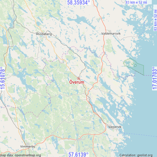
Överum GPS coordinates[2]
57° 59' 18.816" North, 16° 18' 50.04" East
| Map corner | latitude | longitude |
|---|---|---|
| Upper-left | 58.35934°, | 15.61078° |
| Center: | 57.98856°, | 16.3139° |
| Lower-right: | 57.6139°, | 17.01703° |
| Map W x H: | 82.9×82.9 km | = 51.5×51.5mi |
| max Lat: | 67.85572° ⇑60.5% North |
| Överum: | 57.98856° |
| min Lat: | ⇓39.5% South 55.34337° |
| min Long | Överum | max Long |
| 11.1712° | 16.3139° | 24.13676° |
| W 65.5%⇐ | ⇒34.5% E |
Elevation
Elevation of Överum is 64 m = 210 ft, and this is 18.6 m = 61 ft below average elevation for this country.
| Max E: |
663 m = 2175 ft | 42.5% |
| Avg. | 82.6 m = 271 ft | |
| Överum | 64 m = 210 ft | |
Min E: |
-1 m = -3 ft | 57.5% |
See also: Sweden elevation on elevation.city.
Geographical zone
Överum is located in North temperate zone (between Tropic of Cancer and the Arctic Circle). Distance of this North polar circle is 953.5 km =592.5 mi to North.| Distance of | km | miles | from Överum |
|---|---|---|---|
| North Pole | 3559.3 | 2211.6 | to North |
| Arctic Circle | 953.5 | 592.5 | to North |
| Tropic Cancer | 3841.8 | 2387.2 | to South |
| Equator | 6447.7 | 4006.4 | to South |


Nearby cities:
15 places around Överum: (largest is in red/bold)
• Ankarsrum
32.2 km =20 mi,  177°
177°
• Gamleby
11.7 km =7.3 mi,  152°
152°
• Grebo
43.4 km =27 mi,  323°
323°
• Gullringen
41.9 km =26 mi,  239°
239°
• Gunnebo
32.9 km =20.4 mi,  156°
156°
• Gusum
33 km =20.5 mi,  19°
19°
• Horn
30 km =18.6 mi,  250°
250°
• Kisa
40.1 km =24.9 mi,  269°
269°
• Piperskärr
29.6 km =18.4 mi,  140°
140°
• Rimforsa
40.4 km =25.1 mi,  293°
293°
• Ringarum
39.2 km =24.4 mi,  11°
11°
• Södra Vi
41.4 km =25.7 mi,  228°
228°
• Valdemarsvik
29.3 km =18.2 mi,  35°
35°
• Västervik
31.9 km =19.8 mi, 143°
• Åtvidaberg
30.1 km =18.7 mi, 321°
Sources, notices
• [Note1] Compared only with cities in Sweden existing in our database
• [Src1] Map data: © OpenStreetMap contributors (CC-BY-SA)
• [Src2] Other city data from geonames.org with taken over terms of usage.
• [Src3] Geographical zone / Annual Mean Temperature by Robert A. Rohde @ Wikipedia
