Unec geodata
Unec (Cerknica) is a populated place; located in Slovenia in Europe/Ljubljana (GMT+2) time zone. With population of 524 people, there are 521 cities with bigger population in this country. Compared to other cities in Slovenia, 87.7% of cities are located further ↑North; 78% of cities are located further →East and 88.8% of cities have lower elevation than Unec. Note1


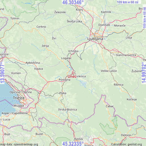
Unec GPS coordinates[2]
45° 48' 56.016" North, 14° 17' 38.004" East
| Map corner | latitude | longitude |
|---|---|---|
| Upper-left | 46.30346°, | 13.59077° |
| Center: | 45.81556°, | 14.29389° |
| Lower-right: | 45.32335°, | 14.99702° |
| Map W x H: | 109×109 km | = 67.7×67.7mi |
| max Lat: | 46.83694° ⇑87.7% North |
| Unec: | 45.81556° |
| min Lat: | ⇓12.3% South 45.47667° |
| min Long | Unec | max Long |
| 13.52639° | 14.29389° | 16.4975° |
| W 22%⇐ | ⇒78% E |
Elevation
Elevation of Unec is 519 m = 1703 ft, and this is 193.4 m = 635 ft above average elevation for this country.
| Max E: |
1551 m = 5089 ft | 11.2% |
| Unec | 519 m 1703 ft | |
| Avg. | 325.6 m = 1068 ft | |
Min E: |
2 m = 7 ft | 88.8% |
See also: Slovenia elevation on elevation.city.
Geographical zone
Unec is located in North temperate zone (between Tropic of Cancer and the Arctic Circle). Distance of this North polar circle is 2307 km =1433.5 mi to North.| Distance of | km | miles | from Unec |
|---|---|---|---|
| North Pole | 4912.8 | 3052.7 | to North |
| Arctic Circle | 2307 | 1433.5 | to North |
| Tropic Cancer | 2488.3 | 1546.2 | to South |
| Equator | 5094.2 | 3165.4 | to South |


Nearby cities:
15 places around Unec: (largest is in red/bold)
• Begunje pri Cerknici
6.9 km =4.3 mi,  87°
87°
• Borovnica
12.4 km =7.7 mi,  25°
25°
• Cerknica
5.9 km =3.7 mi,  115°
115°
• Kalce
11.8 km =7.3 mi,  318°
318°
• Kamnik pod Krimom
17 km =10.6 mi, 30°
• Logatec
12.2 km =7.6 mi,  334°
334°
• Lož
17 km =10.6 mi,  126°
126°
• Pivka
16.6 km =10.3 mi,  207°
207°
• Planina
3.7 km =2.3 mi,  293°
293°
• Postojna
7.6 km =4.7 mi,  233°
233°
• Prestranek
12.6 km =7.8 mi,  221°
221°
• Rakek
1.4 km =0.9 mi,  100°
100°
• Rakitna
14.2 km =8.8 mi,  55°
55°
• Verd
15.7 km =9.8 mi,  3°
3°
• Vrhnika
16.4 km =10.2 mi, 0°
Sources, notices
• [Note1] Compared only with cities in Slovenia existing in our database
• [Src1] Map data: © OpenStreetMap contributors (CC-BY-SA)
• [Src2] Other city data from geonames.org with taken over terms of usage.
• [Src3] Geographical zone / Annual Mean Temperature by Robert A. Rohde @ Wikipedia
