Postojna geodata
Postojna is a seat of a first-order administrative division; located in Slovenia in Europe/Ljubljana (GMT+2) time zone. With population of 9,183 people, there are 16 cities with bigger population in this country. Compared to other cities in Slovenia, 89% of cities are located further ↑North; 80.7% of cities are located further →East and 91.7% of cities have lower elevation than Postojna. Note1


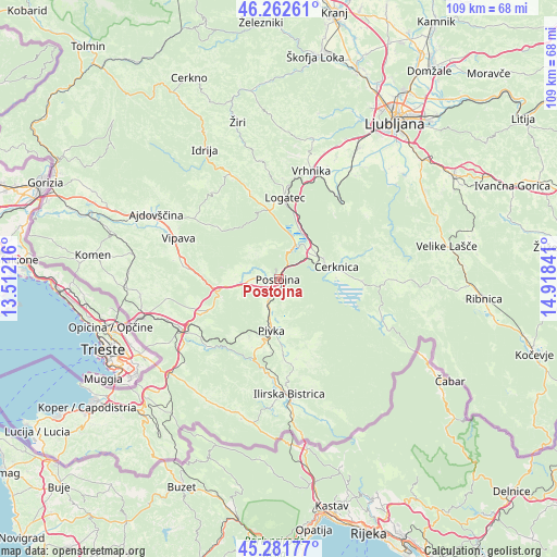
Postojna GPS coordinates[2]
45° 46' 27.66" North, 14° 12' 55.008" East
| Map corner | latitude | longitude |
|---|---|---|
| Upper-left | 46.26261°, | 13.51216° |
| Center: | 45.77435°, | 14.21528° |
| Lower-right: | 45.28177°, | 14.91841° |
| Map W x H: | 109.1×109.1 km | = 67.8×67.8mi |
| max Lat: | 46.83694° ⇑89% North |
| Postojna: | 45.77435° |
| min Lat: | ⇓11% South 45.47667° |
| min Long | Postojna | max Long |
| 13.52639° | 14.21528° | 16.4975° |
| W 19.3%⇐ | ⇒80.7% E |
Elevation
Elevation of Postojna is 548 m = 1798 ft, and this is 222.4 m = 730 ft above average elevation for this country.
| Max E: |
1551 m = 5089 ft | 8.3% |
| Postojna | 548 m 1798 ft | |
| Avg. | 325.6 m = 1068 ft | |
Min E: |
2 m = 7 ft | 91.7% |
See also: Slovenia elevation on elevation.city.
Geographical zone
Postojna is located in North temperate zone (between Tropic of Cancer and the Arctic Circle). Distance of this North polar circle is 2311.5 km =1436.3 mi to North.| Distance of | km | miles | from Postojna |
|---|---|---|---|
| North Pole | 4917.4 | 3055.5 | to North |
| Arctic Circle | 2311.5 | 1436.3 | to North |
| Tropic Cancer | 2483.7 | 1543.3 | to South |
| Equator | 5089.6 | 3162.5 | to South |


Nearby cities:
15 places around Postojna: (largest is in red/bold)
• Begunje pri Cerknici
13.8 km =8.6 mi,  69°
69°
• Borovnica
19.5 km =12.1 mi,  36°
36°
• Cerknica
11.6 km =7.2 mi,  79°
79°
• Hotedršica
18.2 km =11.3 mi,  341°
341°
• Kalce
13.6 km =8.5 mi,  352°
352°
• Logatec
15.6 km =9.7 mi,  3°
3°
• Lož
20.5 km =12.7 mi,  105°
105°
• Pivka
10.3 km =6.4 mi,  188°
188°
• Planina
6.6 km =4.1 mi,  23°
23°
• Prestranek
5.4 km =3.4 mi,  204°
204°
• Rakek
8.6 km =5.3 mi,  59°
59°
• Senožeče
14.8 km =9.2 mi,  246°
246°
• Stari Trg pri Ložu
20.9 km =13 mi, 108°
• Unec
7.6 km =4.7 mi,  53°
53°
• Vipava
21.1 km =13.1 mi,  292°
292°
Sources, notices
• [Note1] Compared only with cities in Slovenia existing in our database
• [Src1] Map data: © OpenStreetMap contributors (CC-BY-SA)
• [Src2] Other city data from geonames.org with taken over terms of usage.
• [Src3] Geographical zone / Annual Mean Temperature by Robert A. Rohde @ Wikipedia
