Planina geodata
Planina (Postojna) is a populated place; located in Slovenia in Europe/Ljubljana (GMT+2) time zone. With population of 815 people, there are 289 cities with bigger population in this country. Compared to other cities in Slovenia, 87.3% of cities are located further ↑North; 79.8% of cities are located further →East and 81.7% of cities have lower elevation than Planina. Note1


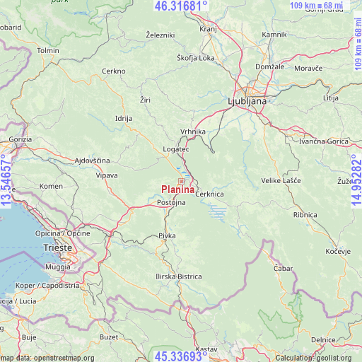
Planina GPS coordinates[2]
45° 49' 44.508" North, 14° 14' 58.884" East
| Map corner | latitude | longitude |
|---|---|---|
| Upper-left | 46.31681°, | 13.54657° |
| Center: | 45.82903°, | 14.24969° |
| Lower-right: | 45.33693°, | 14.95282° |
| Map W x H: | 109×109 km | = 67.7×67.7mi |
| max Lat: | 46.83694° ⇑87.3% North |
| Planina: | 45.82903° |
| min Lat: | ⇓12.7% South 45.47667° |
| min Long | Planina | max Long |
| 13.52639° | 14.24969° | 16.4975° |
| W 20.2%⇐ | ⇒79.8% E |
Elevation
Elevation of Planina is 444 m = 1457 ft, and this is 118.4 m = 388 ft above average elevation for this country.
| Max E: |
1551 m = 5089 ft | 18.3% |
| Planina | 444 m 1457 ft | |
| Avg. | 325.6 m = 1068 ft | |
Min E: |
2 m = 7 ft | 81.7% |
See also: Slovenia elevation on elevation.city.
Geographical zone
Planina is located in North temperate zone (between Tropic of Cancer and the Arctic Circle). Distance of this North polar circle is 2305.5 km =1432.6 mi to North.| Distance of | km | miles | from Planina |
|---|---|---|---|
| North Pole | 4911.4 | 3051.8 | to North |
| Arctic Circle | 2305.5 | 1432.6 | to North |
| Tropic Cancer | 2489.8 | 1547.1 | to South |
| Equator | 5095.7 | 3166.3 | to South |


Nearby cities:
15 places around Planina: (largest is in red/bold)
• Begunje pri Cerknici
10.3 km =6.4 mi,  96°
96°
• Borovnica
13 km =8.1 mi,  42°
42°
• Cerknica
9.6 km =6 mi,  114°
114°
• Hotedršica
14 km =8.7 mi,  323°
323°
• Kalce
8.6 km =5.3 mi,  329°
329°
• Logatec
9.7 km =6 mi,  348°
348°
• Pivka
16.8 km =10.4 mi,  194°
194°
• Postojna
6.6 km =4.1 mi,  203°
203°
• Prestranek
12 km =7.5 mi, 204°
• Rakek
5.1 km =3.2 mi, 110°
• Rakitna
16.4 km =10.2 mi,  66°
66°
• Stara Vrhnika
16.3 km =10.1 mi,  8°
8°
• Unec
3.7 km =2.3 mi, 113°
• Verd
14.8 km =9.2 mi,  17°
17°
• Vrhnika
15.4 km =9.6 mi, 13°
Sources, notices
• [Note1] Compared only with cities in Slovenia existing in our database
• [Src1] Map data: © OpenStreetMap contributors (CC-BY-SA)
• [Src2] Other city data from geonames.org with taken over terms of usage.
• [Src3] Geographical zone / Annual Mean Temperature by Robert A. Rohde @ Wikipedia
