Turčianske Teplice geodata
Turčianske Teplice (Žilinský kraj) is a seat of a second-order administrative division; located in Slovakia in Europe/Bratislava (GMT+2) time zone. In our database, there are 168 cities with bigger population. Compared to other cities in Slovakia, 57.6% of cities are located further ↓South; 55.3% of cities are located further →East and 76.5% of cities have lower elevation than Turčianske Teplice. Note1
Administrative division(s):
- Level 1: Žilinský kraj
- Level 2: Okres Turčianske Teplice
- Level 3: Turčianske Teplice


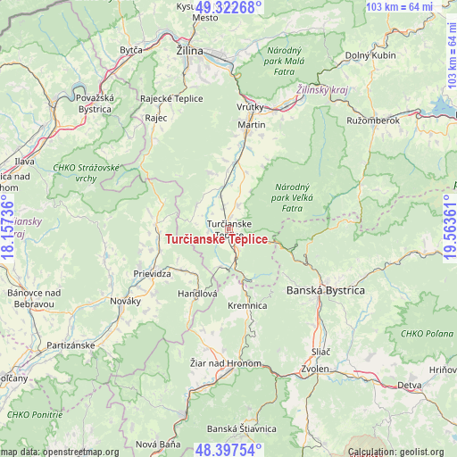
Turčianske Teplice GPS coordinates[2]
48° 51' 44.1" North, 18° 51' 37.728" East
| Map corner | latitude | longitude |
|---|---|---|
| Upper-left | 49.32268°, | 18.15736° |
| Center: | 48.86225°, | 18.86048° |
| Lower-right: | 48.39754°, | 19.56361° |
| Map W x H: | 102.9×102.9 km | = 63.9×63.9mi |
| max Lat: | 49.43503° ⇑42.4% North |
| Turčianske Teplice: | 48.86225° |
| min Lat: | ⇓57.6% South 47.76356° |
| min Long | Turčianske Tep | max Long |
| 16.9786° | 18.86048° | 22.18136° |
| W 44.7%⇐ | ⇒55.3% E |
Elevation
Elevation of Turčianske Teplice is 509 m = 1670 ft, and this is 172.9 m = 567 ft above average elevation for this country.
| Max E: |
1006 m = 3301 ft | 23.5% |
| Turčianske Teplice | 509 m 1670 ft | |
| Avg. | 336.1 m = 1103 ft | |
Min E: |
102 m = 335 ft | 76.5% |
See also: Slovakia elevation on elevation.city.
Geographical zone
Turčianske Teplice is located in North temperate zone (between Tropic of Cancer and the Arctic Circle). Distance of this North polar circle is 1968.2 km =1223 mi to North.| Distance of | km | miles | from Turčianske Teplice |
|---|---|---|---|
| North Pole | 4574.1 | 2842.2 | to North |
| Arctic Circle | 1968.2 | 1223 | to North |
| Tropic Cancer | 2827.1 | 1756.7 | to South |
| Equator | 5433 | 3375.9 | to South |


Nearby cities:
15 places around Turčianske Teplice: (largest is in red/bold)
• Banská Bystrica
25.4 km =15.8 mi,  122°
122°
• Bojnice
21.8 km =13.5 mi,  246°
246°
• Handlová
16.7 km =10.4 mi,  206°
206°
• Kováčová
34 km =21.1 mi,  148°
148°
• Krasňany
39.3 km =24.4 mi,  2°
2°
• Kremnica
18 km =11.2 mi,  166°
166°
• Lehota pod Vtáčnikom
27 km =16.8 mi,  225°
225°
• Martin
23.2 km =14.4 mi,  11°
11°
• Nováky
29.2 km =18.1 mi, 234°
• Prievidza
19.7 km =12.2 mi,  240°
240°
• Rajec
29.9 km =18.6 mi,  327°
327°
• Ružomberok
40.3 km =25 mi,  54°
54°
• Vrútky
28.2 km =17.5 mi, 8°
• Zvolen
38.5 km =23.9 mi, 146°
• Žiar nad Hronom
30.1 km =18.7 mi,  181°
181°
Sources, notices
• [Note1] Compared only with cities in Slovakia existing in our database
• [Src1] Map data: © OpenStreetMap contributors (CC-BY-SA)
• [Src2] Other city data from geonames.org with taken over terms of usage.
• [Src3] Geographical zone / Annual Mean Temperature by Robert A. Rohde @ Wikipedia
