Banská Bystrica geodata
Banská Bystrica (Banskobystrický kraj) is a seat of a first-order administrative division; located in Slovakia in Europe/Bratislava (GMT+2) time zone. With population of 82,336 people, there are 5 cities with bigger population in this country. Compared to other cities in Slovakia, 52.4% of cities are located further ↑North; 52.9% of cities are located further ←West and 61.2% of cities have lower elevation than Banská Bystrica. Note1
Administrative division(s):
- Level 1: Banskobystrický kraj
- Level 2: Okres Banská Bystrica
- Level 3: Banská Bystrica


Banská Bystrica GPS coordinates[2]
48° 44' 22.056" North, 19° 9' 12.564" East
| Map corner | latitude | longitude |
|---|---|---|
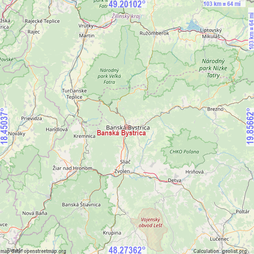
| Upper-left | 49.20102°, | 18.45037° |
| Center: | 48.73946°, | 19.15349° |
| Lower-right: | 48.27362°, | 19.85662° |
| Map W x H: | 103.1×103.1 km | = 64.1×64.1mi |
| max Lat: | 49.43503° ⇑52.4% North |
| Banská Bystrica: | 48.73946° |
| min Lat: | ⇓47.6% South 47.76356° |
| min Long | Banská Bystric | max Long |
| 16.9786° | 19.15349° | 22.18136° |
| W 52.9%⇐ | ⇒47.1% E |
Elevation
Elevation of Banská Bystrica is 351 m = 1152 ft, and this is 14.9 m = 49 ft above average elevation for this country.
| Max E: |
1006 m = 3301 ft | 38.8% |
| Banská Bystrica | 351 m 1152 ft | |
| Avg. | 336.1 m = 1103 ft | |
Min E: |
102 m = 335 ft | 61.2% |
See also: Banská Bystrica elevation on elevation.city.
Geographical zone
Banská Bystrica is located in North temperate zone (between Tropic of Cancer and the Arctic Circle). Distance of this North polar circle is 1981.9 km =1231.5 mi to North.| Distance of | km | miles | from Banská Bystrica |
|---|---|---|---|
| North Pole | 4587.7 | 2850.7 | to North |
| Arctic Circle | 1981.9 | 1231.5 | to North |
| Tropic Cancer | 2813.4 | 1748.2 | to South |
| Equator | 5419.3 | 3367.4 | to South |


Nearby cities:
15 places around Banská Bystrica: (largest is in red/bold)
• Banská Štiavnica
37 km =23 mi,  208°
208°
• Brezno
36.1 km =22.4 mi,  78°
78°
• Detva
27.9 km =17.3 mi,  135°
135°
• Handlová
28.9 km =18 mi,  267°
267°
• Hriňová
32.7 km =20.3 mi,  123°
123°
• Hrochoť,Slovakia
15 km =9.3 mi,  128°
128°
• Kováčová
15.8 km =9.8 mi,  193°
193°
• Kremnica
17.7 km =11 mi,  257°
257°
• Mýto pod Ďumbierom
37.2 km =23.1 mi,  70°
70°
• Prievidza
38.8 km =24.1 mi,  275°
275°
• Ružomberok
38.9 km =24.2 mi,  16°
16°
• Turčianske Teplice
25.4 km =15.8 mi,  302°
302°
• Zvolen
18.4 km =11.4 mi,  180°
180°
• Čierny Balog
36.5 km =22.7 mi,  88°
88°
• Žiar nad Hronom
27.7 km =17.2 mi,  233°
233°
Sources, notices
• [Note1] Compared only with cities in Slovakia existing in our database
• [Src1] Map data: © OpenStreetMap contributors (CC-BY-SA)
• [Src2] Other city data from geonames.org with taken over terms of usage.
• [Src3] Geographical zone / Annual Mean Temperature by Robert A. Rohde @ Wikipedia
