Prievidza geodata
Prievidza (Trenčiansky kraj) is a seat of a second-order administrative division; located in Slovakia in Europe/Bratislava (GMT+2) time zone. With population of 52,987 people, there are 10 cities with bigger population in this country. Compared to other cities in Slovakia, 51.2% of cities are located further ↓South; 62.4% of cities are located further →East and 54.1% of cities have lower elevation than Prievidza. Note1


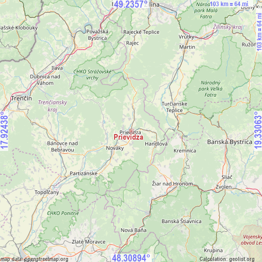
Prievidza GPS coordinates[2]
48° 46' 28.056" North, 18° 37' 39" East
| Map corner | latitude | longitude |
|---|---|---|
| Upper-left | 49.2357°, | 17.92438° |
| Center: | 48.77446°, | 18.6275° |
| Lower-right: | 48.30894°, | 19.33063° |
| Map W x H: | 103×103 km | = 64×64mi |
| max Lat: | 49.43503° ⇑48.8% North |
| Prievidza: | 48.77446° |
| min Lat: | ⇓51.2% South 47.76356° |
| min Long | Prievidza | max Long |
| 16.9786° | 18.6275° | 22.18136° |
| W 37.6%⇐ | ⇒62.4% E |
Elevation
Elevation of Prievidza is 295 m = 968 ft, and this is 41.1 m = 135 ft below average elevation for this country.
| Max E: |
1006 m = 3301 ft | 45.9% |
| Avg. | 336.1 m = 1103 ft | |
| Prievidza | 295 m = 968 ft | |
Min E: |
102 m = 335 ft | 54.1% |
See also: Prievidza elevation on elevation.city.
Geographical zone
Prievidza is located in North temperate zone (between Tropic of Cancer and the Arctic Circle). Distance of this North polar circle is 1978 km =1229.1 mi to North.| Distance of | km | miles | from Prievidza |
|---|---|---|---|
| North Pole | 4583.9 | 2848.3 | to North |
| Arctic Circle | 1978 | 1229.1 | to North |
| Tropic Cancer | 2817.3 | 1750.6 | to South |
| Equator | 5423.2 | 3369.8 | to South |


Nearby cities:
15 places around Prievidza: (largest is in red/bold)
• Banská Bystrica
38.8 km =24.1 mi,  95°
95°
• Bojnice
3.2 km =2 mi,  291°
291°
• Bánovce nad Bebravou
27.8 km =17.3 mi,  257°
257°
• Handlová
11 km =6.8 mi,  118°
118°
• Ilava
37.9 km =23.5 mi,  310°
310°
• Kremnica
22.7 km =14.1 mi,  109°
109°
• Lehota pod Vtáčnikom
9.5 km =5.9 mi,  192°
192°
• Nováky
9.8 km =6.1 mi,  224°
224°
• Partizánske
24.1 km =15 mi,  227°
227°
• Rajec
35 km =21.7 mi,  1°
1°
• Trenčianske Teplice
36.9 km =22.9 mi, 294°
• Turčianske Teplice
19.7 km =12.2 mi,  60°
60°
• Voznica
35.3 km =21.9 mi,  171°
171°
• Žarnovica
33.2 km =20.6 mi, 168°
• Žiar nad Hronom
26 km =16.2 mi,  141°
141°
Sources, notices
• [Note1] Compared only with cities in Slovakia existing in our database
• [Src1] Map data: © OpenStreetMap contributors (CC-BY-SA)
• [Src2] Other city data from geonames.org with taken over terms of usage.
• [Src3] Geographical zone / Annual Mean Temperature by Robert A. Rohde @ Wikipedia
