Bojnice geodata
Bojnice (Trenčiansky kraj) is a populated place; located in Slovakia in Europe/Bratislava (GMT+2) time zone. With population of 4,934 people, there are 110 cities with bigger population in this country. Compared to other cities in Slovakia, 52.9% of cities are located further ↓South; 64.7% of cities are located further →East and 52.4% of cities have lower elevation than Bojnice. Note1


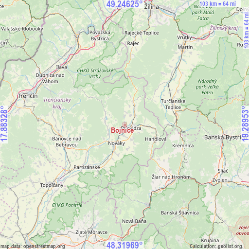
Bojnice GPS coordinates[2]
48° 47' 6.396" North, 18° 35' 11.04" East
| Map corner | latitude | longitude |
|---|---|---|
| Upper-left | 49.24625°, | 17.88328° |
| Center: | 48.78511°, | 18.5864° |
| Lower-right: | 48.31969°, | 19.28953° |
| Map W x H: | 103×103 km | = 64×64mi |
| max Lat: | 49.43503° ⇑47.1% North |
| Bojnice: | 48.78511° |
| min Lat: | ⇓52.9% South 47.76356° |
| min Long | Bojnice | max Long |
| 16.9786° | 18.5864° | 22.18136° |
| W 35.3%⇐ | ⇒64.7% E |
Elevation
Elevation of Bojnice is 283 m = 928 ft, and this is 53.1 m = 174 ft below average elevation for this country.
| Max E: |
1006 m = 3301 ft | 47.6% |
| Avg. | 336.1 m = 1103 ft | |
| Bojnice | 283 m = 928 ft | |
Min E: |
102 m = 335 ft | 52.4% |
See also: Slovakia elevation on elevation.city.
Geographical zone
Bojnice is located in North temperate zone (between Tropic of Cancer and the Arctic Circle). Distance of this North polar circle is 1976.8 km =1228.3 mi to North.| Distance of | km | miles | from Bojnice |
|---|---|---|---|
| North Pole | 4582.7 | 2847.6 | to North |
| Arctic Circle | 1976.8 | 1228.3 | to North |
| Tropic Cancer | 2818.5 | 1751.3 | to South |
| Equator | 5424.4 | 3370.6 | to South |


Nearby cities:
15 places around Bojnice: (largest is in red/bold)
• Bánovce nad Bebravou
25.1 km =15.6 mi,  253°
253°
• Dubnica nad Váhom
36.3 km =22.6 mi,  302°
302°
• Handlová
14.2 km =8.8 mi,  116°
116°
• Ilava
34.9 km =21.7 mi,  312°
312°
• Kremnica
25.9 km =16.1 mi,  110°
110°
• Lehota pod Vtáčnikom
10.5 km =6.5 mi,  174°
174°
• Nová Dubnica
36.2 km =22.5 mi, 297°
• Nováky
9.1 km =5.7 mi,  205°
205°
• Partizánske
22.9 km =14.2 mi,  220°
220°
• Prievidza
3.2 km =2 mi, 111°
• Rajec
34 km =21.1 mi,  6°
6°
• Trenčianske Teplice
33.7 km =20.9 mi,  294°
294°
• Turčianske Teplice
21.8 km =13.5 mi,  66°
66°
• Žarnovica
35.1 km =21.8 mi,  164°
164°
• Žiar nad Hronom
28.9 km =18 mi,  138°
138°
Sources, notices
• [Note1] Compared only with cities in Slovakia existing in our database
• [Src1] Map data: © OpenStreetMap contributors (CC-BY-SA)
• [Src2] Other city data from geonames.org with taken over terms of usage.
• [Src3] Geographical zone / Annual Mean Temperature by Robert A. Rohde @ Wikipedia
